Imagining the Possibilities: Hyperspectral Imaging in Agriculture
on Wed Nov 09 2022

Francis Doumet
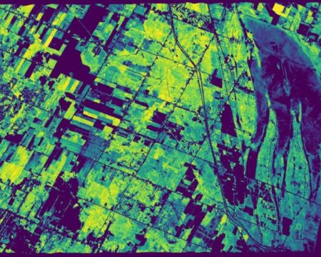
Hyperspectral imaging is a remote sensing technology that can be used to collect data about the physical and chemical properties of an object, scene, or area. In the past, hyperspectral imaging systems were too large, too expensive, and required too much power to be practical for use in agriculture. However, recent advances in technology have made hyperspectral imaging more affordable and accessible than ever before. Farmers can now use hyperspectral imaging to collect detailed information about their crops, soil, and water resources.
The hyperspectral images that are collected can be analyzed to reveal important information about the health of crops, the presence of pests or diseases, and the nutrient content of soil. This information can be used to improve crop yields, optimize irrigation schedules, and reduce the need for chemical inputs. In addition, hyperspectral imaging can be used to monitor environmental conditions such as air quality and atmospheric composition.
How Hyperspectral Imaging Works
Hyperspectral imaging systems consist of a sensor that collects data across a wide range of wavelengths, a processor that translates the data into images, and software that analyzes the images to extract information about the object or scene being imaged. The wavelength range of most hyperspectral imagers used in agriculture extends from the visible light spectrum (400-700 nm) into the near-infrared spectrum (700-1000 nm). This allows them to collect data about an object’s reflectance, absorption, and fluorescence at very high resolutions.
Hyperspectral imagers are usually mounted on unmanned aerial vehicles (UAVs), satellites, or manned aircraft. When mounted on UAVs or satellites, they are often referred to as multispectral imagers because they only collect data in specific spectral bands that are chosen to match the needs of the application. For example, a multispectral imager designed for agricultural applications might only collect data in the near-infrared region of the electromagnetic spectrum because plants reflect most light in this region.
While multispectral imagers can provide useful information about an object or scene, they are limited by the number of spectral bands that they can detect. Hyperspectral imagers do not have this limitation because they can collect data across a continuous range of wavelengths. This allows them to potentially detect thousands of different spectral signatures which makes them far more sensitive than multispectral imagers.
Applications of Hyperspectral Imaging in Agriculture
Hyperspectral imaging can be used for a variety of different applications in agriculture including crop mapping, yield estimation, irrigation scheduling, soil characterization, and pest detection. Farmers can use hyperspectral images to map their crops so that they know exactly where each type of crop is growing. This information can then be used to estimate yields using crop models that take into account factors like plant density and leaf area index.
Farmers can also use hyperspectral images to detect irrigation problems such as leaks or overflows. By monitoring changes in plant reflectance over time, farmers can optimize their irrigation schedules to reduce water usage without harming crop yields. Additionally, hyperspectral images can be used to characterize soils so that farmers know exactly what nutrients are present and how best to fertilize their crops.
Finally, hyperspecteral images can also be used to detect pests such as insects or weeds. By analyzing changes in plant reflectance across different wavelengths, it is possible to identify pests even when they are very small and difficult to see with the naked eye. This information can then be used by farmers to take action before pests have a chance to cause serious damage to their crops.
Conclusion
When it comes to agricultural applications, hyperspecteral imaging holds great potential for farmers looking to increase yields while reducing water usage and chemical inputs. This technology has only recently become affordable and accessible but it is already being used for a variety tasks such as crop mapping yield estimation, irrigation scheduling, soil characterization, and pest detection. As more farmers adopt this technology, we will likely see even more innovative applications for it in the years ahead .