Mapping and Detection of Methane Emissions with PRISMA and ENMAP
on Tue Jun 10 2025

Guillaume
Methane emissions are a significant environmental issue, contributing to global warming and climate change. Methane is a potent greenhouse gas, with a warming potential around 28 times greater than carbon dioxide over a 100-year period. It accounts for about 30% of global warming since pre-industrial times and is proliferating faster than ever before. The primary sources of methane emissions include agriculture, particularly from livestock, fossil fuel production and use, and the decomposition of waste in landfills. An estimated 60% of today’s methane emissions are the result of human activities, with the remainder coming from natural sources like wetlands. Reducing methane emissions is crucial for mitigating climate change and slow global temperature increases.
Advanced hyperspectral satellite sensors like PRISMA and ENMAP, which provide freely and openly accessible imagery, have been shown to be very useful in monitoring anthropogenic methane emissions. Indeed, both satellites offer high spatial resolution, around 30 meters, and spectral coverage of the shortwave infrared region (SWIR) that allow for the subtle detection and attribution of methane plumes to specific sources. This capability is crucial for pinpointing and mitigating methane leaks from various industrial activities, thereby supporting global efforts to reduce greenhouse gas emissions.
However, extracting methane emissions information from these data sources is still a tedious task that requires expert knowledge. To solve this issue, Metaspectral is excited to announce its new GeoMonitoring platform, which allows seamless retrieval of methane emissions and flux for any region of interest (ROI) selected by the user. This platform performs the hyperspectral image processing, methane enhancement computation and carbon flux estimation in the background, bringing only the most important and useful insights directly to the user in a streamlined fashion. Let’s dive a bit deeper into this new solution, exploring methane emissions from the Oil & Gas industry and from Landfills.
Mapping leaks in the Oil & Gas industry
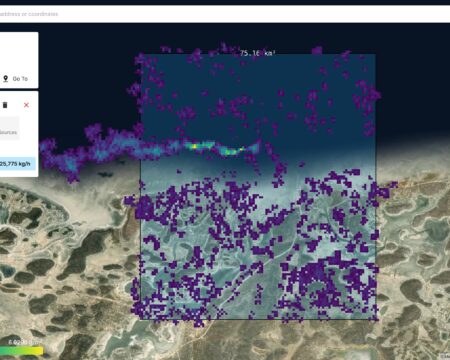
Our GeoMonitoring platform has demonstrated consistent performance in detecting significant methane emissions from an Oil & Gas site near the northern Caspian Sea in Kazakhstan. Leveraging PRISMA hyperspectral imagery, the platform estimated an emission rate of 25.7 t/h on August 3, 2023 (Figure 1), closely aligning with the 28.5 t/h (±6.1 t/h) reported in another study.
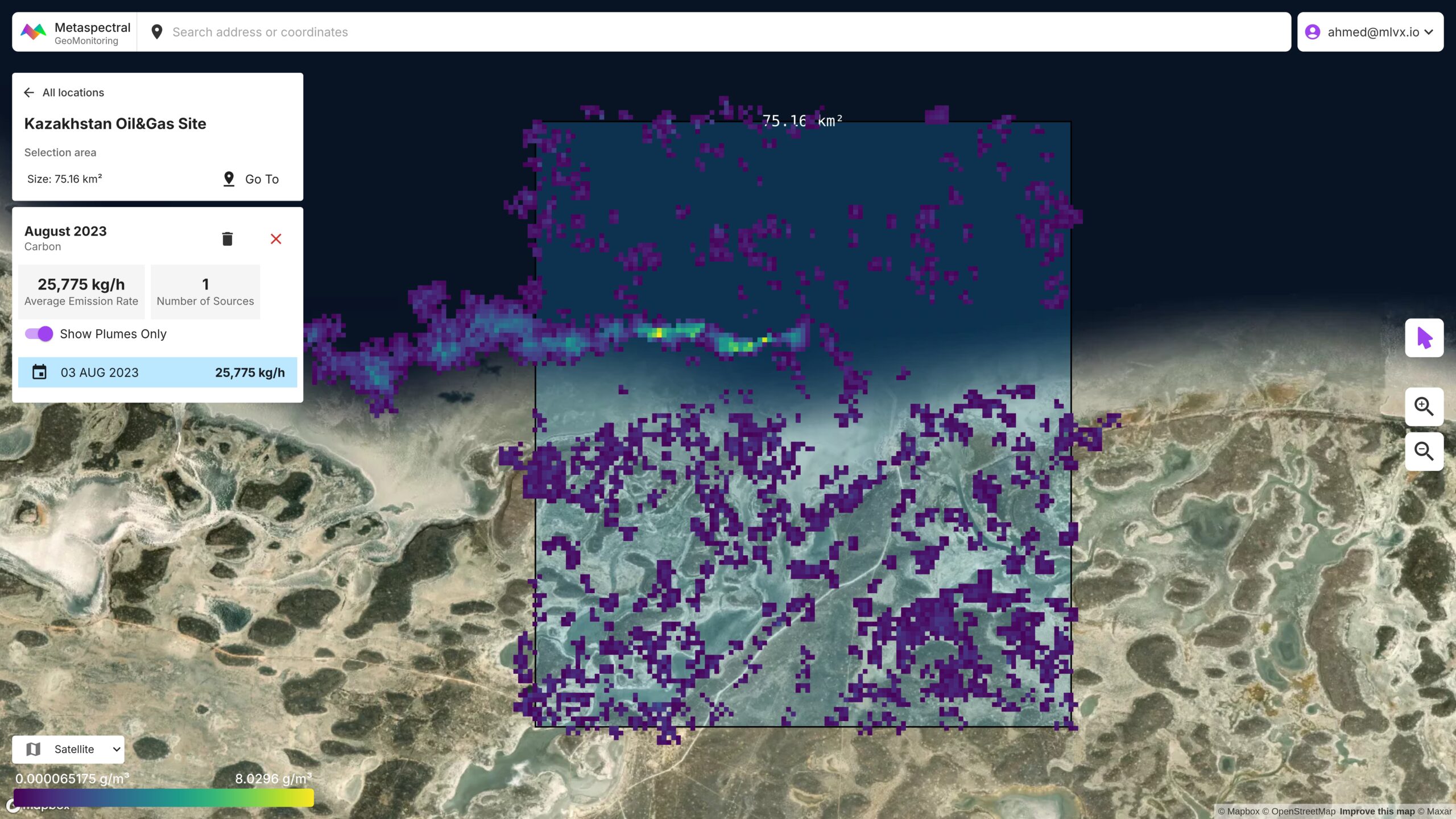
A follow-up detection on September 19, 2023, revealed an emission rate of 22.3 t/h, which corresponds well with the study’s reported value of 22.7 t/h (±9.1 t/h) for the same date (Figure 2).
Both emissions were traced to a wellhead at 45.3335° N, 52.3714° E. The strong agreement between our platform’s estimates and the published data underscores its reliability in quantifying methane leaks and supports timely response and mitigation efforts in the Oil & Gas sector.
Mapping emissions from landfills
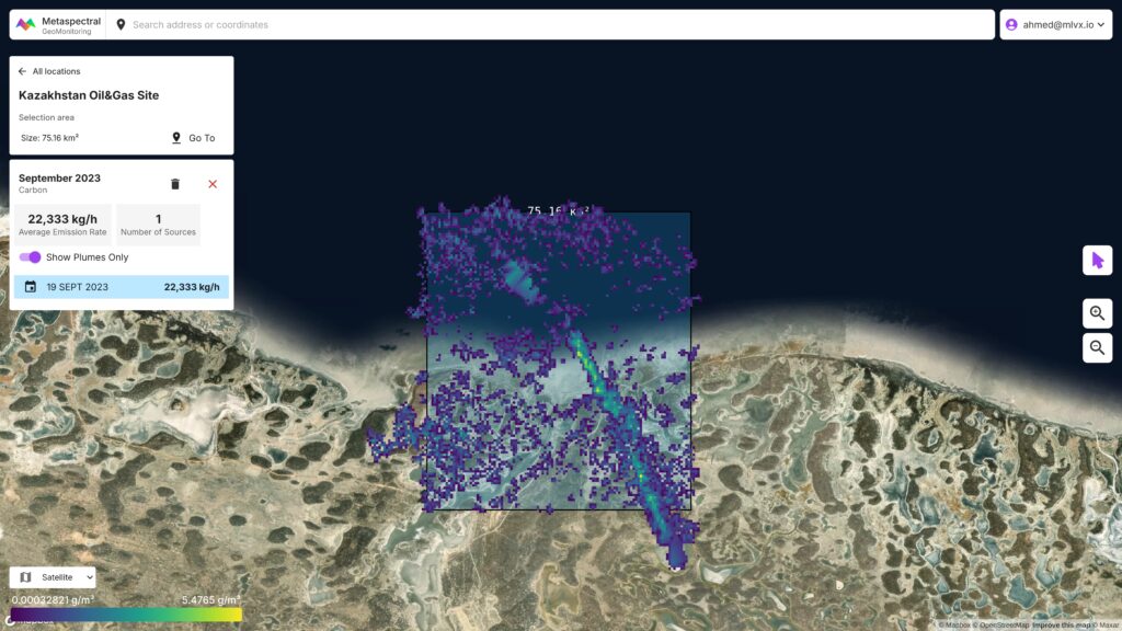
Methane emissions from Landfills constitute a large anthropogenic source in rapidly growing urban regions. Our GeoMonitoring platform was employed to analyze emissions from the Bhalswa landfill in New Delhi – one of the city’s most active waste disposal sites, located at 28.7399° N, 77.1574° E.
Carbon Mapper previously reported methane emissions from this site on September 1, 2022, detecting a plume with an estimated emission rate of 1.9 t/h (±0.4 t/h) using the EMIT instrument aboard the ISS (source). This observation provides a strong baseline reference for comparison with subsequent satellite-based assessments.
Our platform independently analyzed PRISMA hyperspectral imagery for the same location and detected a methane emission rate of 1.5 t/h on December 13, 2022 (Figure 3).
Detecting emissions from landfills
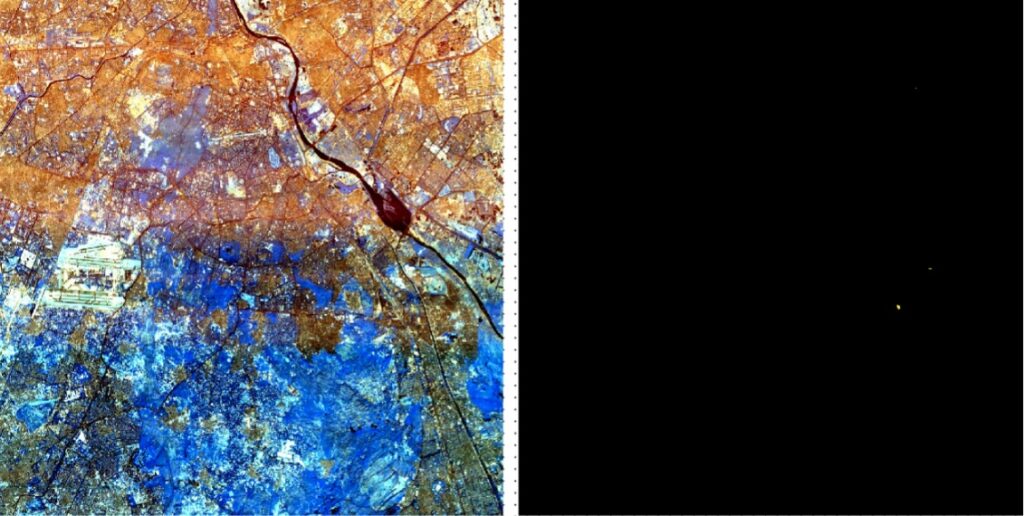
Metaspectral also trained a Deep Learning target detection model using synthetic spectra generated by means of a radiative transfer model (RTM). This approach differs from the one presented above in that, rather than quantifying the methane emissions, it simply tells the user whether or not an abnormal amount of methane was detected in comparison with the background atmospheric concentration. This is particularly useful when a user is only interested in pinpointing anthropogenic emission sources. Here, we ran this target detector on the ENMAP imagery of the Okhla landfill, also located in the vicinity of New Delhi (28.5119° N, 77.2842° E).
Carbon Mapper previously reported methane emissions from this site on October 17, 2024, detecting a plume with an estimated emission rate of 297 Kg/h (±123 Kg/h) using the Tanager satellite from Planet (source).
Even though the emission rate was very low, the location of this source was identified by our target detector based on ENMAP imagery from October 30, 2024. This emission source is represented by the bright yellow dot on the right hand side of Figure 4.
Final Thoughts
Hyperspectral imaging, which captures data across a wide range of the electromagnetic spectrum, is emerging as a transformative technology in Earth observation. While traditional remote sensing has relied on RGB and multispectral imaging, hyperspectral imaging can provides richer datasets, enabling new and more detailed analysis of the Earth’s surface and atmosphere. Recognizing the potential of hyperspectral imaging, numerous companies are developing and launching commercial hyperspectral satellite sensors. These include Planet, Pixxel, Orbital Sidekick, Sidus Space, Wyvern, and Kuva Space among others. These initiatives will expand the availability of hyperspectral data dramatically, opening up new possibilities for applications in environmental monitoring, agriculture, mineral exploration, security and other fields.
Through its methane measurement demonstration using open-source PRISMA and ENMAP data, Metaspectral demonstrates not only the potential of hyperspectral imaging as a reliable and accurate monitoring tool but also the effectiveness and innovation of its hyperspectral imagery processing platform and capabilities. Indeed, one of the challenges posed by hyperspectral imaging is handling the massive volume of data it generates. Analyzing and interpreting this data efficiently requires specialized tools and expertise. Metaspectral’s cloud-based platform addresses this challenge by providing a scalable and flexible solution for hyperspectral data processing. By leveraging cloud computing resources and advanced algorithms, Metaspectral enables users to seamlessly extract valuable insights from hyperspectral data quickly and easily, unlocking new possibilities for scientific research, commercial applications, and environmental sustainability.