Emulating Expert Systems for Global Mineral Mapping: Scalable, Sensor-Agnostic Mineralogical Retrieval Powered by Clarity
on Tue Feb 24 2026

Guillaume

Introduction
The EMIT mission (Earth Surface Mineral Dust Source Investigation), deployed on the ISS, maps surface mineralogy in arid regions globally. Mineral retrieval is performed by the USGS Tetracorder expert system, a knowledge-based, heuristic spectral identification framework that applies continuum removal, multi-feature absorption analysis, and expert-encoded rules to produce physically consistent mineral maps.
Tetracorder’s robustness and high fidelity make it the gold standard for imaging spectroscopy-based mineralogy. However, adapting this approach for next-generation commercial hyperspectral constellations, such as Planet Labs’ Tanager, Orbital Sidekick’s GHOSt, and Pixxel’s Firefly, is hindered by Tetracorder’s reliance on manual, expert-driven configuration. While the algorithm is computationally efficient, its requirement for setup and configuration creates an architectural bottleneck for the automated and large-scale data processing required. Metaspectral’s Clarity platform directly addresses this challenge, providing a scalable, cloud-native environment to train, deploy, and interpret deep learning emulators that preserve Tetracorder’s expert logic.
Approach
We present a 1D-CNN emulator developed and trained on Clarity, Metaspectral‘s hyperspectral AI platform, designed to replicate Tetracorder’s per-pixel mineral classification outputs. By encoding decades of expert spectroscopic logic into a deployable, parallelizable model, Clarity enables any operator to generate expert-quality mineralogical products at constellation scale. Eight minerals were targeted: Calcite, Chlorite, Dolomite, Goethite, Hematite, Kaolinite, Montmorillonite, and Illite+Muscovite.
Training Data
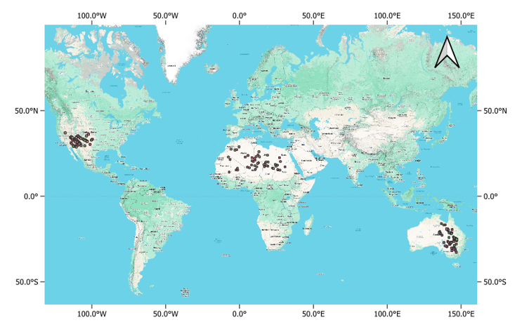
150 EMIT L2A reflectance and L2B mineralogy scenes were ingested and processed within Clarity across three arid geographic regions (Figure 1): USA, North Africa (NA), and East Australia (EA), spanning January 2023 to January 2025. Labels were derived from Tetracorder band depths scaled by USGS XRD factors, with pixels filtered by soil fraction (>0.5), quality masks, and two diagnostic uncertainty metrics: Fit Score (FS) and Band Depth Uncertainty (BDU).
Model Architecture & Explainability on Clarity
A dual-scale 1D-CNN was trained entirely within Clarity, processing per-pixel reflectance spectra through parallel narrow- and wide-kernel convolutional branches that capture both fine-grained absorption features and broader spectral envelopes. Local models were trained for each geographic region (USA, NA & EA) and a global model was trained encompassing all regions. Clarity’s built-in explainable AI module was used to generate spectral heatmaps, providing transparent, band-level attribution for every mineral class prediction, a capability that is critical for scientific validation and trust.
Cross-Sensor Transfer
A Transfer Model was developed to bridge spectral discrepancies between Tanager-1 and EMIT. Using co-located acquisitions over Cuprite, Nevada (a canonical spectral geology benchmark), a transfer model was computed to map Tanager spectra into EMIT spectral space prior to inference — demonstrating Clarity’s capacity to operationalize a single trained model across multiple sensors.
Key Findings
Local vs. Global Modelling
Performances of global and local models are presented in Table 1. The local model for USA achieved the highest accuracy (0.91 OA / 0.91 F1). Many sites in the USA, like Cuprite, consist of well-exposed, high-purity mineralogy which produces high-confidence spectral signatures. In contrast, the ancient surfaces of East Australia and the specific mineral assemblages of North Africa often involve intricate sub-pixel mixing and soil background interference which might explain the lower accuracies obtained for these regions. The global models achieved performances intermediate between the local model for USA and those for EA and NA, but sufficient for planetary-scale climate modeling applications. This result was expected as handling a more diverse dataset in the global model comes at the expense of accuracy.
| Models | Validation | Test | ||
| OA | F1 | OA | F1 | |
| GLOBAL | 0.88 | 0.88 | 0.84 | 0.84 |
| LOCAL (NA) | 0.85 | 0.84 | 0.83 | 0.83 |
| LOCAL (EA) | 0.87 | 0.87 | 0.84 | 0.84 |
| LOCAL (USA) | 0.93 | 0.93 | 0.91 | 0.91 |
Explainable AI
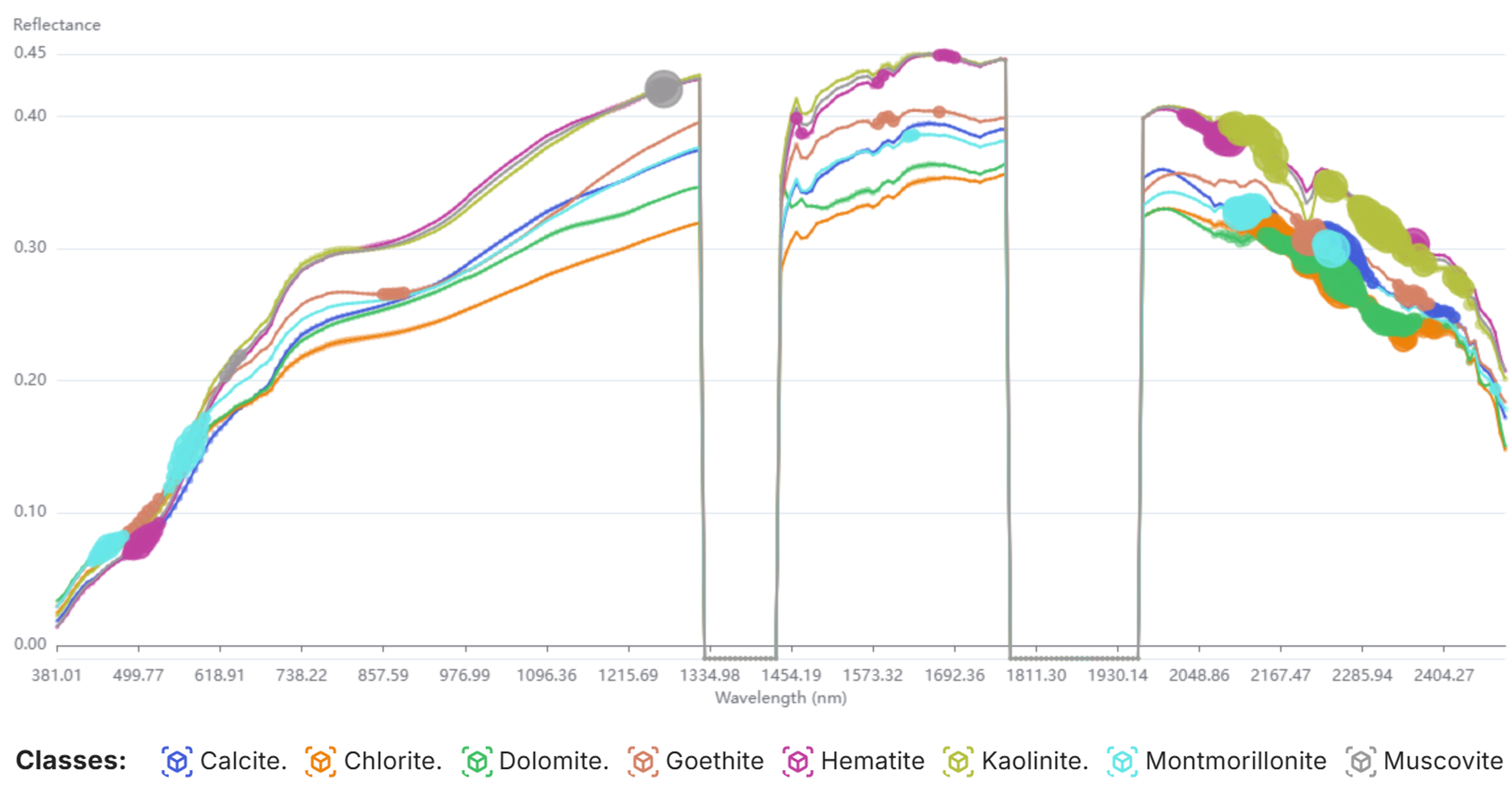
Clarity’s spectral heatmaps (Figure 2) confirm that the emulator learns physically meaningful spectral features rather than spurious correlations. Phyllosilicates (chlorite, kaolinite, muscovite, montmorillonite) are discriminated primarily via Al-OH (~2200 nm) and Mg-OH/Fe-OH (~2300–2400 nm) absorptions. Iron oxides (goethite, hematite) are identified through Fe³⁺ electronic transitions in the VNIR (400–900 nm). Carbonates (calcite, dolomite) are resolved from CO₃ vibrational fundamentals and overtones between 2200 and 2350 nm. Notably, the model also captures secondary diagnostic features (Fe²⁺ substitution in muscovite at 1275 nm, and Fe-OH vibrational bands in goethite at 2200–2300 nm), demonstrating that the emulator leverages the same multi-feature logic inherent in Tetracorder’s expert rule base.
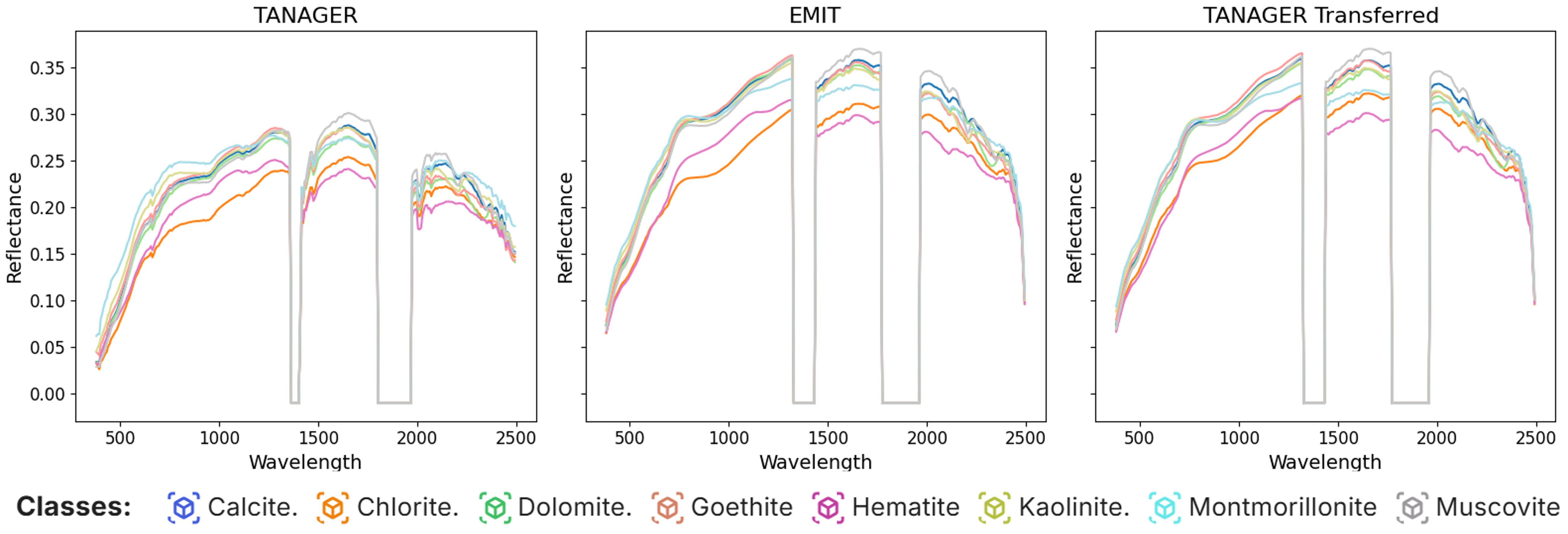
Cross-Sensor Transfer: Tanager to EMIT
The transfer model successfully aligned Tanager’s spectral space with EMIT’s, as evidenced by near-identical average class spectra shown in Figure 3.
The global model applied to Tanager transferred imagery produced mineral maps (Figure 4) with high spatial coherence relative to the original labels at both Cuprite and the independent validation site of Ajo, Arizona (a porphyry copper deposit). Accurate delineation of the Cuprite hydrothermal core (Kaolinite) from its surrounding phyllic halo (Illite/Muscovite), and of the Ajo phyllic/propylitic transition (Illite/Muscovite vs. Calcite), confirms that the emulator preserves mineralogical rigor across sensors and geographies.
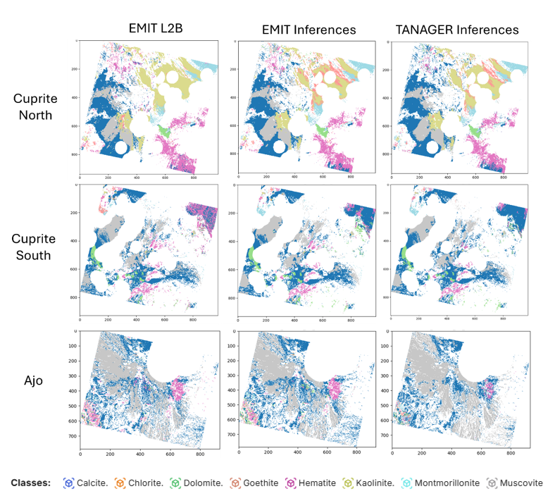
It worth pointing out that the classification approach presented here serve as a baseline. Future work aims to using unmixing networks to output fractional abundances directly. This would allow the model to represent the true physical reality of the Earth’s surface, where minerals rarely exist in pure, isolated pixel blocks.
The Clarity Advantage
This work demonstrates that Metaspectral’s Clarity is uniquely positioned to deliver expert-level mineralogical mapping at constellation scale, autonomously and across sensors. By packaging the rigor of USGS Tetracorder into a cloud-deployable deep learning model, Clarity enables mineral mapping operators, satellite constellation providers, and geoscience organizations to generate high-fidelity mineral products on demand, from any hyperspectral sensor.
The validated cross-sensor pipeline, from EMIT training to Tanager inference, establishes a clear commercial pathway for onboarding new sensors onto the Clarity platform with minimal additional effort. Clarity’s built-in explainable AI provides scientifically defensible, band-level transparency into every prediction, an increasingly important requirement for regulatory applications and trust.
