PLANET TANAGER × METASPECTRAL CLARITY
From Multispectral Monitoring to Material Intelligence
A practical FAQ for teams adding hyperspectral depth to established Earth observation workflows
Most earth observation teams already rely on multispectral imagery for coverage, cadence, cost efficiency, familiar indices, GIS compatibility, and operational maturity. Hyperspectral extends those workflows when the next decision requires more specific evidence than broad spectral bands can provide.
Multispectral imagery is excellent at showing where something changed. Hyperspectral imagery adds the spectral detail to investigate what changed, why it changed, and whether the evidence is strong enough to act on. Clarity turns that added information into reviewable material intelligence for applications such as material identification, vegetation chemistry, gas detection, and subtle target discrimination.
Clarity is a hyperspectral-first platform built for high-dimensional spectral analysis. It also brings multispectral imagery and other geospatial inputs into the workflow as context, baselines, triggers, and supporting evidence, allowing teams to retain familiar monitoring systems while adding more specific diagnostic capability.
This FAQ focuses on teams evaluating Planet Tanager. Its Tanager-specific guidance sits within a broader analysis and validation framework that also applies to other hyperspectral sources.
Discuss your Earth observation use case with Metaspectral to define the decision, compare suitable sensor and workflow options, and establish validation criteria for an operational program.
Where hyperspectral adds the next level of evidence
A practical path from monitoring to material intelligence
- Build on multispectral where it already provides the right monitoring signal.
- Add hyperspectral where the team needs material-specific evidence, better separation of causes, or higher-confidence review.
- Use Clarity to validate and operationalize the added spectral information.
| Customer situation | What multispectral already gives them | What hyperspectral adds | How Clarity helps |
|---|---|---|---|
| A team already monitors large areas with PlanetScope, Sentinel-2, aerial imagery, or other MSI sources | Repeat coverage, operational familiarity, visual context, and established indices | A targeted diagnostic layer when broad-band signals do not explain the cause or material condition | Preserves the existing monitoring layer while adding hyperspectral analysis where it changes the decision |
| MSI flags change, but the team cannot confidently identify the cause | Fast detection of change, stress, disturbance, or anomaly | Narrow-band spectral evidence tied to materials, gases, minerals, vegetation chemistry, or mixed targets | Tests whether hyperspectral evidence separates the causes that the current workflow combines |
| The decision depends on material identity, composition, or subtle target discrimination | Useful context and proxy indicators | Directly relevant spectral features that can support classification, detection, unmixing, or anomaly review | Converts high-dimensional spectral data into reviewable outputs, evidence panels, exports, and reports |
| The buyer needs to justify a new data source or workflow | A known operational baseline | A candidate improvement that can be tested against the current process | Runs a structured evaluation before the customer commits to recurring acquisitions or production integration |
Tanager · unmixing
One index, three material fractions
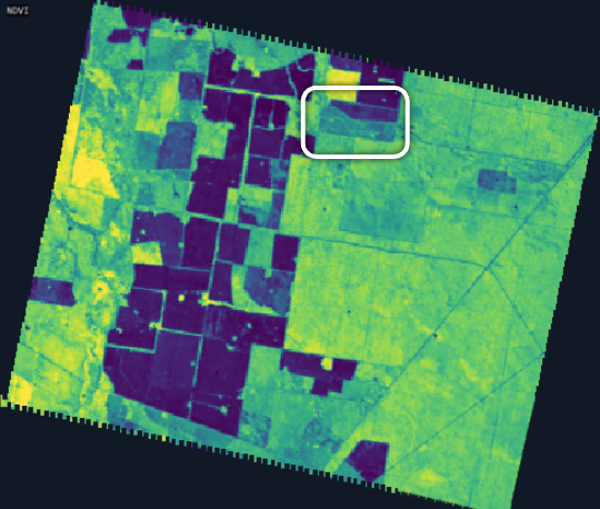
Monitoring baselineNDVI
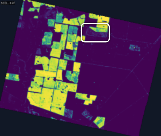
Material fractionSoil
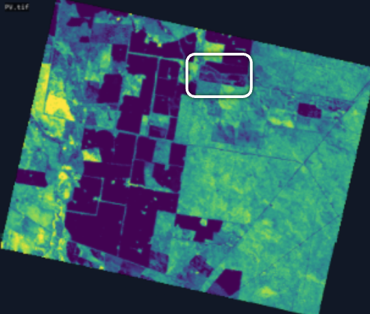
Material fractionPV
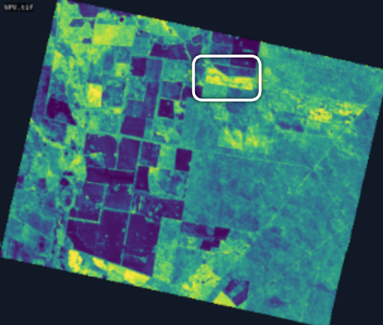
Clarity evidenceNPV
Section 1 — From multispectral monitoring to hyperspectral evidence
1. What does hyperspectral add to a mature multispectral workflow?
Hyperspectral imagery adds a material-level evidence layer to workflows that already use multispectral data for monitoring, context, and change detection.
A multispectral workflow can show that vegetation stress, surface disturbance, mineral alteration, plume activity, or another signal is present. That is valuable, and in many operational programs it is the correct first layer. The limitation is that broad spectral bands often combine multiple physical or chemical causes into the same index or visual pattern. A stressed crop, an exposed mineral unit, or a surface anomaly may be visible without being specifically identified.
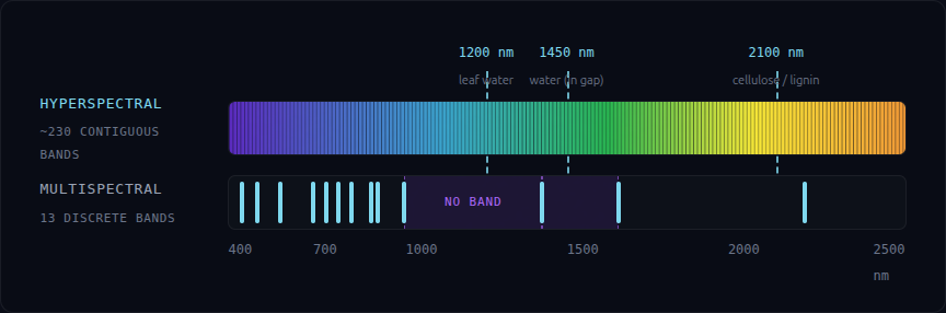
Hyperspectral data records hundreds of narrower spectral measurements. Those measurements can reveal absorption features and spectral shapes associated with materials, gases, minerals, vegetation chemistry, and other target conditions. In the right use case, this shifts the workflow from observing change to diagnosing what the change likely means.
Multispectral imagery remains the operational baseline and often the trigger. A typical workflow is:
- use multispectral data for broad monitoring and cadence;
- use hyperspectral data when the team needs a more specific material or biochemical answer; and
- use Clarity to turn that high-dimensional spectral data into reviewable outputs, evidence, exports, and repeatable workflows.
Hyperspectral delivers the most value when it reduces uncertainty, prioritizes field work, separates look-alike signals, or supports a decision that broad-band imagery cannot resolve with enough confidence.
Why the added bands matter
Sparse bands vs. a continuous spectrum
2. When should a team add hyperspectral data to an existing multispectral workflow?
A team should consider adding hyperspectral data when the current workflow already identifies an area or condition of interest, but the next decision requires more specific evidence than broad-band imagery can provide.
Good triggers include:
- The current index is useful but ambiguous. NDVI, NDRE, clay ratios, false-colour composites, and other broad-band indicators can highlight change without identifying the underlying cause.
- The decision depends on material identity. The team needs to distinguish among minerals, gases, vegetation conditions, surface materials, or target classes that can look similar in multispectral data.
- The cost of being wrong is high. Field deployment, drilling, sampling, inspection, treatment, or reporting decisions are expensive enough that better evidence can create real operational value.
- The team needs a defensible review process. The output must be tied to evidence, confidence context, known limitations, and repeatable evaluation—not just a visual map.
- The workflow can tolerate targeted acquisition. Hyperspectral data is often best used selectively, not necessarily as a one-for-one replacement for high-cadence multispectral monitoring.
Most teams keep multispectral imagery for monitoring, add hyperspectral data for diagnosis, validate the result in Clarity, and export the output back into their existing systems.
Clarity supports that process by organizing the candidate inputs, establishing the customer’s current baseline, testing hyperspectral outputs against explicit success criteria, and helping determine whether the added spectral information improves the decision enough to move into production.
3. How does Clarity use the multispectral data and workflows my team already has?
Clarity can use multispectral and other geospatial data as context, baselines, change triggers, comparison layers, or supporting evidence within a broader workflow.
An established multispectral stack already contains valuable operational knowledge: areas of interest, time-series patterns, indices, review habits, ground-truth records, GIS layers, and downstream reporting processes. Clarity carries that context into the hyperspectral workflow.
Typical roles for multispectral data inside a Clarity-centered workflow include:
- identifying where change occurred before a targeted hyperspectral analysis;
- providing spatial and temporal context around a Tanager or other hyperspectral acquisition;
- serving as the baseline that a hyperspectral workflow must outperform;
- supporting analyst review alongside hyperspectral outputs;
- helping define areas of interest, background classes, or exclusion zones; and
- feeding exported results back into the customer’s existing GIS or operational process.
Clarity remains hyperspectral-first. Its deepest differentiation comes from high-dimensional spectral analysis, model evaluation, spectral evidence review, and repeatable material-intelligence workflows. It adds a higher-information spectral layer to monitoring and decision processes that customers already use.
4. When does a combined multispectral and hyperspectral workflow make the most sense?
A combined workflow is often the strongest option when the customer needs both frequency and spectral specificity.
Multispectral imagery can provide broad, recurring surveillance of a large area. It can identify change, prioritize an area of interest, or show where conditions have departed from a baseline. A hyperspectral acquisition can then be used to investigate the material or biochemical characteristics associated with that change.
Examples include:
- Agriculture: multispectral imagery monitors field-scale change and vegetation trends; hyperspectral data is used selectively to investigate biochemical stress indicators or to prioritize scouting.
- Mining and geology: multispectral imagery provides regional mapping and structural context; hyperspectral data is used to distinguish alteration minerals or refine targets.
- Environmental monitoring: multispectral imagery tracks disturbance and land-cover change; hyperspectral data is used to investigate surface materials, contamination indicators, or vegetation condition.
- Emissions monitoring: broad-area monitoring and facility context can be combined with hyperspectral gas detection and follow-up inspection.
This is commonly described as a tip-and-cue workflow: one source identifies where attention is needed, and another provides more specific evidence. It can also be a co-analysis workflow in which both sources are evaluated together.
Clarity supports the combined process by importing the relevant imagery, aligning the analysis with the operational question, and preserving the contribution of each source in the delivered output. Multispectral data supplies cadence and context; hyperspectral data supplies material-specific evidence.
Section 2 — Satellite hyperspectral in the sensor mix: Tanager edition
5. What does a satellite hyperspectral source like Planet Tanager add?
A satellite hyperspectral source like Tanager adds scalable access to high-dimensional visible and shortwave-infrared spectral information from orbit. For teams that already use multispectral imagery, the important shift is not simply “more bands.” It is the ability to investigate material composition, gas absorption, vegetation chemistry, and other spectral properties that broad-band sensors may only approximate.
Planet currently lists the Tanager system at 424 bands spanning 400–2,500 nm, approximately 5 nm spectral spacing, 30 m spatial resolution, an 18 km swath, six sensitivity modes, and a weekly revisit rate. Planet offers calibrated radiance and atmospherically corrected surface-reflectance products for customers that want to conduct application-specific analysis.
Those specifications matter because many materials and gases exhibit diagnostic absorption features within the visible, near-infrared, or shortwave-infrared range. Instead of measuring a small number of broad spectral bands, Tanager records a much more detailed spectral profile for each pixel. That profile can provide evidence about composition or condition that may not be available from broader-band imagery.
Tanager adds a targeted spectral evidence layer to higher-resolution, higher-cadence, and lower-cost monitoring sources. It is most relevant when:
- the target has a detectable signature within Tanager’s spectral range;
- the target or its aggregate signal is compatible with 30 m spatial resolution;
- a weekly or tasking-based acquisition model is compatible with the decision cadence;
- atmospheric and scene quality are sufficient for the intended analysis; and
- the added spectral information can be validated against the customer’s operational baseline.
In a Planet-centered workflow, Tanager can complement PlanetScope or other Planet products. Broad monitoring and spatial context can identify where to look, while Tanager can add a more detailed spectral view of selected areas or conditions. Clarity then helps configure the analysis, review the evidence, validate the output, and deliver results into the customer’s workflow.
6. How does Tanager compare with airborne hyperspectral systems and other satellite sources?
Source selection starts with the decision requirement and balances spatial resolution, spectral resolution, signal-to-noise performance, coverage, revisit, cost, tasking flexibility, and operational availability.
Airborne hyperspectral systems can provide high spatial resolution, flexible flight planning, and strong data quality over a targeted area. They are often well suited to detailed site characterization, research campaigns, and projects where a customer can justify aircraft mobilization. Their limitations are typically campaign cost, logistics, repeatability, and the difficulty of scaling frequent acquisitions across large or geographically dispersed areas.
Spaceborne hyperspectral systems trade some spatial and acquisition flexibility for broader access, repeatable collection, and a more scalable operational model. Tanager’s 30 m imagery will not replace an airborne survey where fine-scale discrimination is essential. It may be a better fit where the customer needs scheduled coverage across multiple sites, a repeatable satellite data product, or integration with other Planet imagery.
Compared with other spaceborne hyperspectral sources, Tanager should be evaluated on current availability, tasking model, spectral range, sensitivity, product type, delivery, cost, licensing, revisit, and fit with the customer’s target. Planet states that Tanager is three to six times more sensitive than comparable spaceborne systems across its spectral range, but sensitivity alone does not establish use-case performance. The relevant test is whether the delivered data supports reliable detection or classification for the customer’s target and environment.
Metaspectral compares candidate sources against the same decision and validation criteria, then configures Clarity around the data best suited to the target and operating environment.
7. Which applications are a strong technical fit for Tanager data?
A strong fit generally has three characteristics:
- The target produces a diagnostic signal within Tanager’s visible-to-shortwave-infrared range.
- The target is large enough, concentrated enough, or statistically detectable at 30 m spatial resolution.
- The decision does not require a cadence faster than the available acquisition and delivery process.
Potential application areas include:
Mining and geology
Tanager may support mapping and discrimination of alteration minerals, clays, iron oxides, carbonates, sulfates, and other materials with established spectral features. The strongest applications are those where the target mineral assemblage is expressed at a scale compatible with the imagery and where geological or field evidence is available for validation.
Agriculture and vegetation
Hyperspectral data may provide information related to chlorophyll, water content, nitrogen, lignin, cellulose, and other biochemical or structural conditions. The analytical objective should be specific: for example, prioritizing areas for scouting, testing whether a stress indicator appears before visible damage, or distinguishing among conditions that a broad vegetation index may combine.
Emissions monitoring
Tanager’s core mission includes methane and carbon-dioxide monitoring. Planet offers derived methane products as well as core hyperspectral imagery. The appropriate workflow depends on whether the customer needs Planet’s derived gas products, a custom Clarity analysis, or a combined process with facility context and follow-up review.
Environmental monitoring
Potential applications include surface-material mapping, mine-rehabilitation monitoring, contamination screening, vegetation-condition assessment, and change analysis in managed or disturbed landscapes. These use cases require careful treatment of mixed pixels, atmospheric effects, seasonal variation, and ground validation.
Technical fit depends on the target, geography, season, data quality, operating cadence, and available validation evidence.
8. What Tanager limitations should a buyer account for before designing a workflow?
Tanager’s operating constraints shape the acquisition, analysis, and validation design. Testing them early establishes whether the workflow can perform reliably in production.
Spatial resolution
At 30 m, small or narrow targets may be mixed with surrounding materials. Sub-pixel analysis may help in some cases, but it cannot recover information that is not present with sufficient signal quality. The evaluation should determine whether the target occupies enough of the pixel, has a strong enough signature, or occurs in a spatial pattern that can be detected reliably.
Revisit and tasking
Planet currently lists a weekly revisit rate for Tanager. That cadence is not equivalent to PlanetScope’s near-daily monitoring. Workflows that require rapid or continuous updates may need a combined sensor strategy or a different data source.
Cloud and atmospheric conditions
Like other optical systems, Tanager depends on usable atmospheric and illumination conditions. Hyperspectral analysis is particularly sensitive to absorption features and calibration quality. Planet offers both calibrated radiance and atmospherically corrected surface-reflectance products; the correct product and any additional preprocessing should be selected for the use case.
Spectral and spatial mixing
A 30 m pixel may contain several materials, vegetation types, or land-cover conditions. The analysis must distinguish between a strong target signature, a mixed signal, and background variability. This is one reason validation and uncertainty review are essential.
Data volume and computation
Hundreds of bands create larger data products and more demanding analysis than conventional multispectral imagery. Customers should account for data movement, storage, preprocessing, model execution, and export requirements. Clarity is designed to handle high-dimensional spectral workflows, but the production architecture still needs to be scoped around the customer’s data volumes and operating environment.
Reference evidence
Reliable performance depends on knowing what constitutes success. Reference spectra, field observations, assays, inspection records, historical maps, or withheld test areas may be needed to validate the output. Without an appropriate reference, a visually convincing result can still be operationally weak.
A structured Metaspectral evaluation establishes sensor fit, scene quality, analytical performance, and business value before the customer commits to recurring acquisitions or a production integration.
Section 3 — From data to operational outputs in Clarity
9. What does Metaspectral Clarity actually do with Earth observation data?
Clarity helps teams move from a spectral or geospatial data product to a reviewable output tied to a decision. The exact workflow depends on the source data, target, and operating requirement, but it generally includes five stages.
1. Ingest and organize
The customer or project team brings the relevant data into Clarity. Inputs may include hyperspectral imagery, multispectral context, reference spectra, labels, field observations, existing maps, or other supporting geospatial data.
2. Assess quality and prepare the data
The workflow checks whether the scene and product are suitable for the intended analysis. Depending on the source product, this may include confirming calibration, reviewing atmospheric or cloud effects, selecting usable bands, aligning supporting data, and preparing the analysis area.
3. Analyze
The appropriate method is selected for the problem. This may include spectral comparison, target detection, classification, anomaly detection, spectral unmixing, change analysis, or a trained model. Not every use case requires the same method, and not every use case requires deep learning.
4. Review and validate
Clarity supports inspection of the analytical result, the underlying spectral evidence, the confidence or uncertainty context available for the workflow, and the areas that require additional review. The output should be compared with reference evidence and the customer’s acceptance criteria.
5. Deliver and repeat
The resulting data products, maps, review notes, or reports are exported for use in the customer’s downstream process. Once a workflow has been validated, it can be documented and rerun on new acquisitions, subject to monitoring for changes in sensor, geography, season, target, or data quality.
Clear problem definition anchors the workflow. Clarity gives the customer and Metaspectral a shared environment for making the analytical process repeatable, inspectable, and operationally useful.
10. What does the customer receive from a Clarity workflow?
The deliverable is defined during scoping and should match the decision the customer needs to make. Depending on the use case, it may include:
- target or anomaly maps;
- material or mineral class layers;
- crop-stress or vegetation-condition layers;
- plume-detection and monitoring packages;
- spectral evidence panels;
- confidence or uncertainty context;
- analyst review notes;
- exported geospatial or analytical data products;
- model-evaluation results;
- validation or blind-scoring reports; and
- a structured summary of findings, limitations, and recommended follow-up.
A useful output connects the mapped result to the evidence behind it. It shows what was detected, where the result is strong or weak, which assumptions shaped the analysis, and what additional validation may be needed.
The output package is agreed in advance so the analysis is judged against a practical standard tied to the customer’s decision.
11. How do data import, export, and integrations work?
The current standard pattern is straightforward:
- Bring data into Clarity. Data is imported into Clarity through the agreed project workflow, including programmatically through the API. For a Tanager project, the imagery is obtained through Planet and then brought into Clarity through the agreed import path.
- Run the analysis and review process in Clarity. The workflow is configured around the target, scene, supporting data, validation method, and output requirement.
- Export data and results. The customer can export the relevant data products and analytical outputs for use in its GIS, analytics, reporting, or operational environment.
For an evaluation or proof of concept, the data exchange may be managed as an assisted process so the team can focus on technical fit. For production use, the workflow can be automated through the API or through a scoped integration.
Additional integrations can be scoped around the customer’s environment. Relevant requirements may include:
- source and destination systems;
- data and output formats;
- authentication and access controls;
- data volume and transfer frequency;
- cloud, on-premises, or restricted-environment constraints;
- orchestration and monitoring requirements; and
- the review or approval step before an output enters an operational process.
Clarity fits into the customer’s existing stack through a defined production design that specifies where data enters, where analysis occurs, what is exported, and which team reviews and acts on the result.
12. Do I need to train a model to use Clarity?
Not necessarily. Some workflows can begin with established spectral methods, reference spectra, target detectors, anomaly analysis, or other configured analytical processes. A trained model is useful when the problem requires learning complex target variation, separating mixed materials, classifying recurring patterns, or scaling a validated analytical task across many scenes.
The appropriate approach depends on the available evidence:
- Reference-spectrum workflow: a customer has one or more known target signatures and wants to detect or compare them across a scene.
- Configured analytical workflow: the task can be addressed with a repeatable combination of preprocessing, band selection, spectral comparison, thresholds, and analyst review.
- Adapted model: an existing model or workflow is refined for the customer’s sensor, geography, target, or operating condition.
- New model: the project requires training and validating a model against customer-provided labels, field data, reference spectra, synthetic mixtures, or other representative examples.
Clarity’s deep-learning and spectral-analysis capabilities are designed primarily for high-dimensional hyperspectral data. Hundreds of contiguous bands provide a rich feature space for target detection, classification, unmixing, and anomaly analysis. Multispectral data remains valuable as context, cueing, comparison, or baseline, while the hyperspectral layer can be trained, tested, reviewed, and operationalized in Clarity.
Metaspectral determines whether a model is necessary, assesses whether the available data can support training and validation, and develops the model strategy with the customer.
13. How are models configured, tested, refined, and deployed?
A model should be treated as part of an operational system, not as a one-time training exercise. The process should include the following stages.
Define the decision and acceptance criteria
Before training begins, the team defines the decision the model will support, the required output, the acceptable false-positive and false-negative rates, the review process, and the evidence needed before deployment.
Establish the data and baseline
The team assesses source imagery, reference spectra, labels, field observations, existing methods, and scene quality. The customer’s current workflow becomes the baseline against which the new approach is measured.
Configure or train
The analytical method is selected and configured. Where training is needed, the project may use customer examples, reference spectra, synthetic data, or a combination of sources. Training data should be separated from the data used for final evaluation.
Test on held-out or blind data
Performance should be measured on data the model did not use during training. In a blind-area evaluation, the customer can withhold known results until Clarity has completed the analysis. This provides stronger evidence than reviewing performance only on a familiar training scene.
Review errors and refine
False positives, missed detections, mixed signals, and ambiguous areas are examined. The workflow may be refined through updated training examples, threshold changes, preprocessing adjustments, additional reference data, or a narrower definition of the operational task.
Approve the operating workflow
The team agrees on the production input, output, review step, integration path, monitoring expectations, and conditions that require revalidation. Deployment should occur only after the model and process meet the agreed criteria.
Monitor and update
Performance can change with a new sensor, geography, season, atmospheric condition, target composition, or operating environment. A production workflow should include a process for detecting drift, reviewing unexpected outputs, and deciding when the model or thresholds must be updated.
Clarity supports this lifecycle while the customer and its qualified reviewers retain final interpretation and action. Models, evidence, thresholds, and errors remain available for inspection, challenge, and improvement.
Section 4 — Reviewable material intelligence, validation, and value
14. What does Metaspectral mean by “material intelligence”?
A classification map assigns a label, score, or category to part of an image. Material intelligence goes further by connecting the analytical result to the material or condition being investigated, the evidence available in the data, and the decision the customer needs to make.
A useful material-intelligence output should help the reviewer answer four questions:
- What does the data indicate? The analysis identifies a target, class, material signature, anomaly, or condition relevant to the task.
- Where is the evidence strongest? The output shows the areas most consistent with the target or class definition.
- Where is the result uncertain or mixed? The workflow identifies conditions that should not be overinterpreted.
- What should happen next? The result supports a practical next action such as inspection, sampling, scouting, field validation, additional acquisition, or continued monitoring.
This distinction matters because an operational team rarely needs a spectral label for its own sake. A geologist needs to decide where to inspect or sample. An agronomist needs to decide where to send scouts. An environmental team needs to decide what to investigate, monitor, or report. Material intelligence is the reviewed, contextualized evidence that helps support that next decision.
The specific evidence and confidence representation depend on the workflow. For each application, Metaspectral defines the review artifacts, confidence context, and validation method during scoping so the customer knows what the output can and cannot support.
15. How does Clarity support trustworthy AI and technical validation?
Clarity is designed to support expert review, not to remove it. Analytical outputs are intended to help customer teams inspect data, compare evidence, prioritize follow-up, and make decisions within their established processes. Final interpretation and action remain with the customer.
A trustworthy workflow should include:
- a clearly defined purpose and decision boundary;
- documented input data and preprocessing choices;
- explicit success and failure criteria;
- separation of training and evaluation data where a model is used;
- review of false positives, missed detections, mixed signals, and edge cases;
- evidence or context that allows a qualified reviewer to inspect the result;
- a clear statement of limitations and conditions under which the result should not be used; and
- an agreed process for field, laboratory, expert, or operational validation.
Metaspectral supports several validation structures:
Known-area benchmark
Run a well-documented area and compare the output with accepted maps, field records, or public reference data.
Blind area-of-interest validation
Use a historical site where the customer already knows the answer, withhold that answer during analysis, and score the Clarity result against the customer’s records.
Validation-partner study
Combine imagery with field, laboratory, assay, inspection, scouting, or other real-world observations collected by a qualified partner.
The right metrics depend on the task. They may include precision and recall, false-positive reduction, detection threshold, class accuracy, analyst review time, output quality, decision usefulness, or the ability to identify a target that the existing workflow misses.
A trustworthy result makes uncertainty and supporting evidence visible so the customer can decide whether it is fit for the intended use.
Planetary Intelligence: observation, interpretation, and action
Planet’s broader Planetary Intelligence vision emphasizes the value of turning recurring Earth observation into information that can support real-world decisions. In this workflow, Tanager contributes rich hyperspectral observation. Clarity contributes analysis, review context, and repeatable delivery. The customer contributes domain expertise, validation, and responsibility for action.
High-frequency multispectral monitoring, targeted hyperspectral acquisition, contextual imagery, field observations, and customer records can all contribute to the same decision process. Clarity brings those inputs together and turns the relevant spectral evidence into outputs that teams can review and use.
16. How do I determine the economic value and begin an evaluation?
Start with the decision, the current baseline, and the cost of being wrong.
A useful business case should answer:
- What operational decision will the output support?
- What data and method are used today?
- What does the current workflow cost in data, analyst time, field work, delay, or missed opportunity?
- What are the consequences of a false positive, false negative, or late detection?
- What measurable improvement would justify a new data source or workflow?
- How often must the result be produced?
- What evidence is required before the result can be trusted?
- What integration and review burden would the production workflow introduce?
Hyperspectral information creates the most value when it changes an expensive or high-consequence decision. It may help avoid unnecessary drilling, reduce broad field treatment, prioritize inspection, narrow a sampling program, identify a material or condition earlier, or strengthen monitoring and reporting. A structured evaluation measures that improvement against the current workflow.
Metaspectral recommends the following process:
- Discuss the use case. Share the decision problem, current workflow, area of interest, available data, and operating constraints.
- Select the candidate technology. Compare a targeted hyperspectral evaluation, a combined multispectral-and-hyperspectral workflow, and a phased rollout from the current monitoring baseline.
- Define the output and success criteria. Agree on what the customer must receive and how the result will be judged.
- Run a structured evaluation. Use representative data and, where possible, a known-area, blind-area, or validation-partner design.
- Review the evidence and business case. Compare the result with the existing baseline, including technical performance, analyst effort, integration burden, and cost.
- Decide whether to operationalize. Proceed only when the value, limitations, review process, and production integration are understood.
The resulting program may use Tanager with Clarity, another hyperspectral source, or a combined multispectral-and-hyperspectral workflow. In each case, the customer retains its monitoring investment and adds material-level evidence where the evaluation shows measurable value.
Discuss your Earth observation use case
After the use case has been framed, a guided demonstration or the Planet Tanager sandbox can show relevant analysis patterns. Validation on the customer’s data and decision criteria establishes production fit.
Sources and related pages
- Planet Hyperspectral
- Planet Tanager constellation and current specifications
- Planet Tanager × Metaspectral Clarity
- Emulating Expert Systems for Global Mineral Mapping
- Metaspectral Earth Observation
- Metaspectral EO Validation
- Discuss an EO Use Case
- Metaspectral AI Review and Decision Support