Emulating Expert Systems for Global Mineral Mapping: Scalable, Sensor-Agnostic Mineralogical Retrieval Powered by Clarity
Metaspectral's Clarity platform delivers automated, expert-level mineral mapping from hyperspectral data, scalable across EMIT, Tanager, and next-gen satellite constellations.
Guillaume
Senior Research Scientist
Callout, ContentBreak, Figure, PullQuote, WideImage, } from "@/components/blog";
Introduction
The EMIT mission, short for Earth Surface Mineral Dust Source Investigation, is deployed on the ISS and maps surface mineralogy in arid regions around the world.
Mineral retrieval is performed by the USGS Tetracorder expert system, a knowledge-based spectral identification framework that uses continuum removal, multi-feature absorption analysis, and expert-encoded rules to produce physically consistent mineral maps. Tetracorder’s robustness and fidelity have made it the gold standard for imaging spectroscopy-based mineralogy.
The problem is not scientific rigor. The problem is operational scale.
Adapting Tetracorder for next-generation commercial hyperspectral constellations such as Planet Labs’ Tanager, Orbital Sidekick’s GHOSt, and Pixxel’s Firefly is difficult because the system still depends on manual, expert-driven configuration. While the underlying algorithm is computationally efficient, setup and configuration create a bottleneck for the automated, large-scale data processing now required by commercial programs.
Metaspectral’s Clarity platform addresses that bottleneck by providing a scalable, cloud-native environment to train, deploy, and interpret deep learning emulators that preserve Tetracorder’s expert logic.
Approach
We developed and trained a 1D-CNN emulator on Clarity, Metaspectral’s hyperspectral AI platform, to replicate Tetracorder’s per-pixel mineral classification outputs.
By encoding decades of expert spectroscopic logic into a deployable, parallelizable model, Clarity enables operators to generate expert-quality mineralogical products at constellation scale. The model targeted eight minerals:
- Calcite
- Chlorite
- Dolomite
- Goethite
- Hematite
- Kaolinite
- Montmorillonite
- Illite + Muscovite
Training data
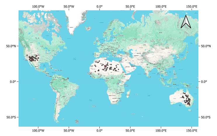
150 EMIT L2A reflectance and L2B mineralogy scenes were ingested and processed within Clarity across three arid geographic regions: the USA, North Africa, and East Australia. The training period spanned January 2023 through January 2025.
Labels were derived from Tetracorder band depths scaled by USGS XRD factors. Pixels were filtered by soil fraction above 0.5, quality masks, and two diagnostic uncertainty metrics: Fit Score (FS) and Band Depth Uncertainty (BDU).
Model architecture and explainability on Clarity
A dual-scale 1D-CNN was trained entirely within Clarity. The model processes per-pixel reflectance spectra through parallel narrow- and wide-kernel convolution branches so it can capture both fine-grained absorption features and broader spectral envelopes.
Local models were trained for each geographic region, and a global model was trained across all regions. Clarity’s explainable AI module was then used to generate spectral heatmaps, producing band-level attribution for each mineral class prediction. That transparency is important for both scientific validation and user trust.
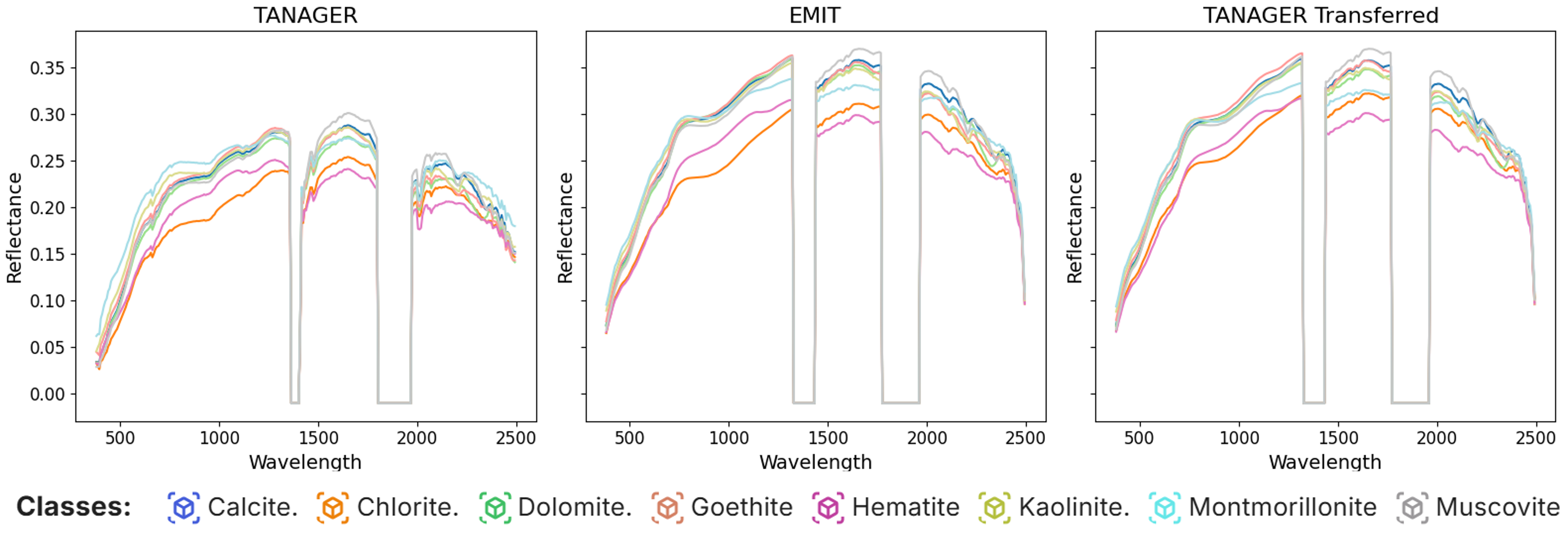
Cross-sensor transfer
A transfer model was developed to bridge spectral discrepancies between Tanager-1 and EMIT.
Using co-located acquisitions over Cuprite, Nevada, a canonical spectral geology benchmark, the team computed a transfer model that maps Tanager spectra into EMIT spectral space prior to inference. This demonstrates how a single trained model can be operationalized across multiple sensors inside Clarity.
"The practical breakthrough is not just classification accuracy. It is being able to carry expert mineral logic from one sensor environment into another without rebuilding the whole workflow from scratch.
Key findings
Local vs. global modeling
Global and local model performance show a familiar tradeoff between specialization and scale.
The local model for the USA achieved the strongest result at 0.91 overall accuracy / 0.91 F1 on test data. Sites in the USA, such as Cuprite, often contain well-exposed, high-purity mineralogy that produces strong and high-confidence spectral signatures.
By contrast, East Australia and North Africa include more intricate sub-pixel mixing and stronger soil background interference, which likely contributes to lower accuracy. The global models performed between the strongest USA local model and the weaker regional models, but still remained suitable for planetary-scale climate-modeling applications.
| Model | Validation OA | Validation F1 | Test OA | Test F1 |
|---|---|---|---|---|
| Global | 0.88 | 0.88 | 0.84 | 0.84 |
| Local (NA) | 0.85 | 0.84 | 0.83 | 0.83 |
| Local (EA) | 0.87 | 0.87 | 0.84 | 0.84 |
| Local (USA) | 0.93 | 0.93 | 0.91 | 0.91 |
Explainable AI
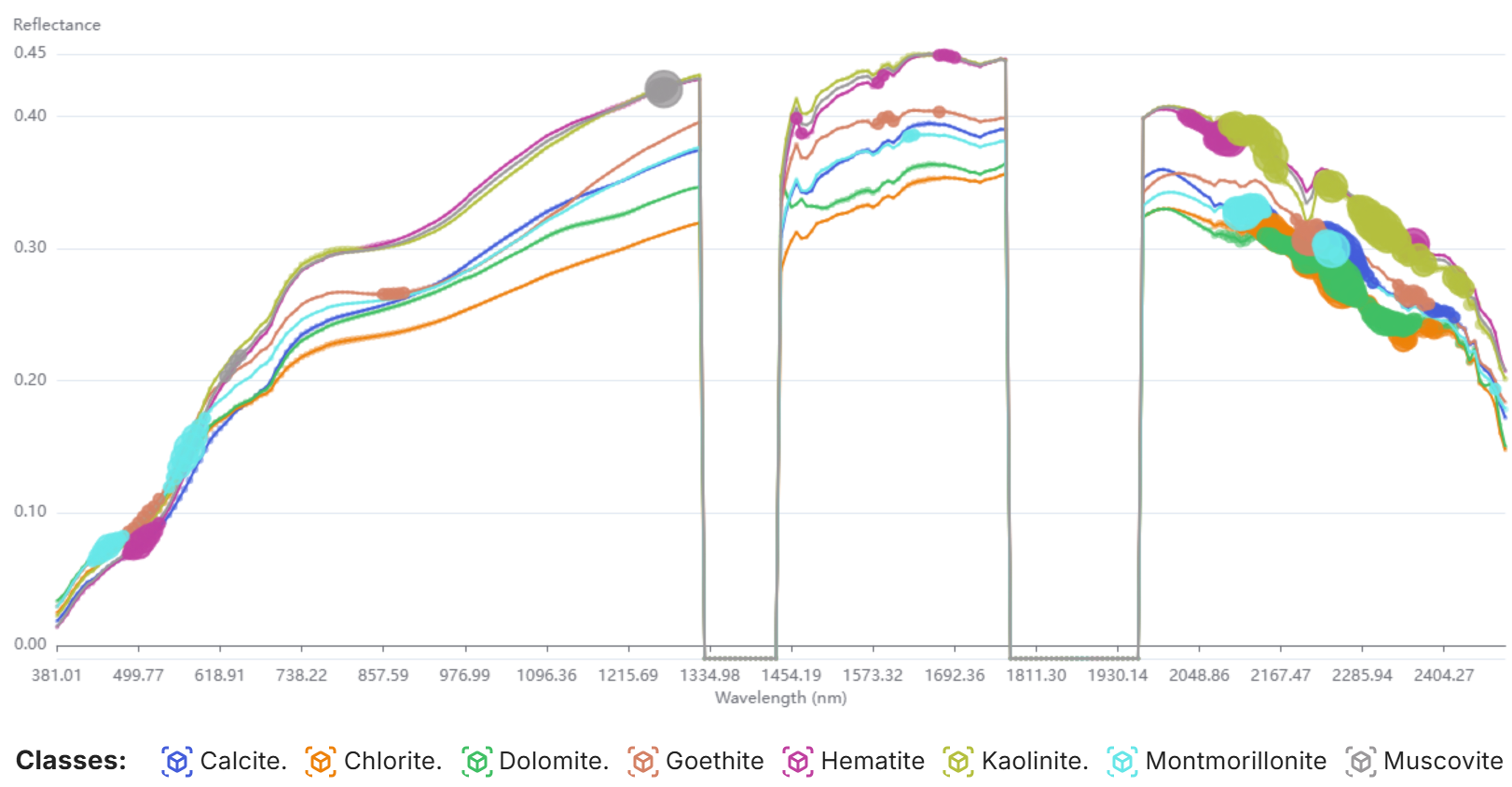
Clarity’s spectral heatmaps confirm that the emulator is learning physically meaningful spectral features rather than spurious correlations.
Phyllosilicates such as chlorite, kaolinite, muscovite, and montmorillonite are separated primarily through Al-OH and Mg-OH/Fe-OH absorptions. Iron oxides such as goethite and hematite are identified through Fe³⁺ electronic transitions in the VNIR. Carbonates such as calcite and dolomite are resolved from CO₃ vibrational fundamentals and overtones between 2200 and 2350 nm.
The model also captures secondary diagnostic features, including Fe²⁺ substitution in muscovite at 1275 nm and Fe-OH vibrational bands in goethite at 2200 to 2300 nm. That is strong evidence that the emulator is leveraging the same multi-feature logic embedded in Tetracorder’s expert rule base.
Cross-sensor transfer from Tanager to EMIT
The transfer model successfully aligned Tanager’s spectral space with EMIT’s, as shown by near-identical average class spectra over Cuprite.
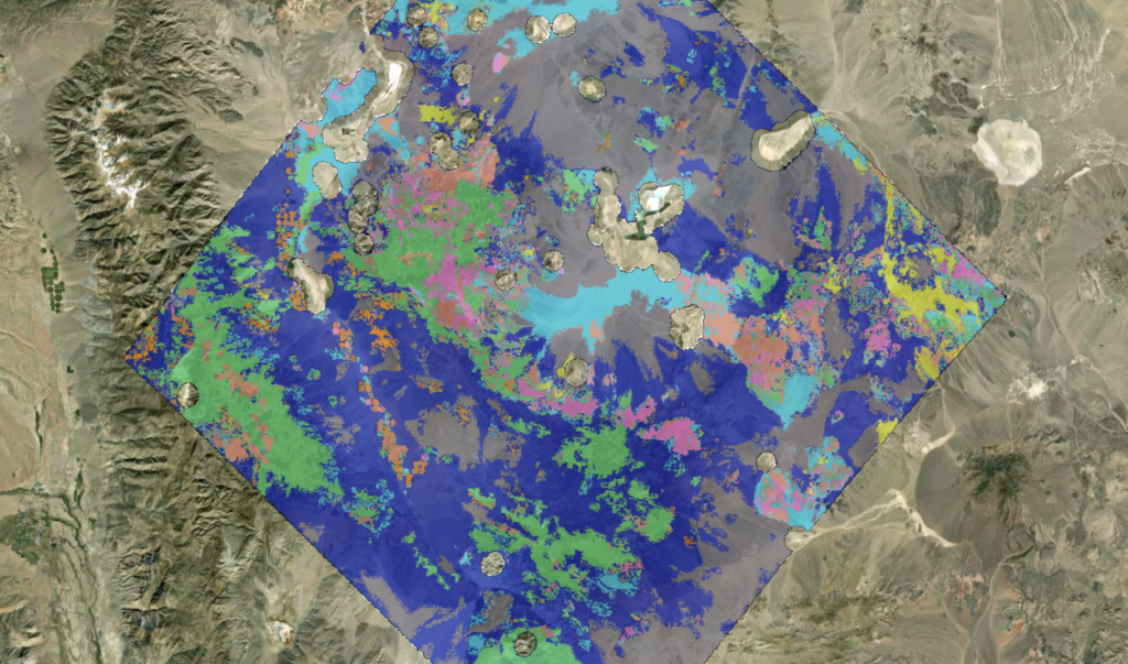
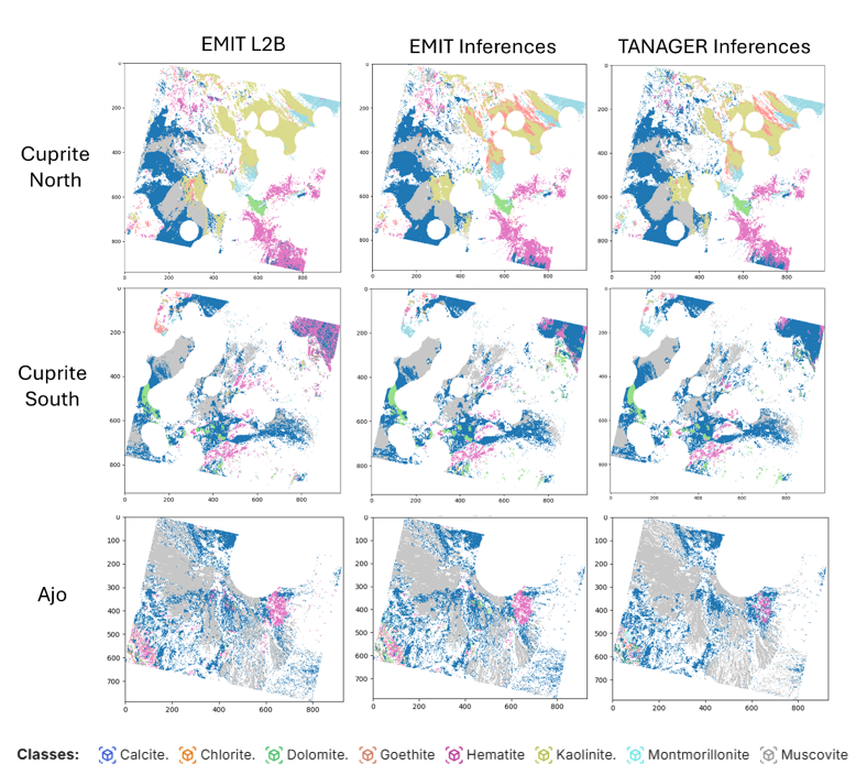
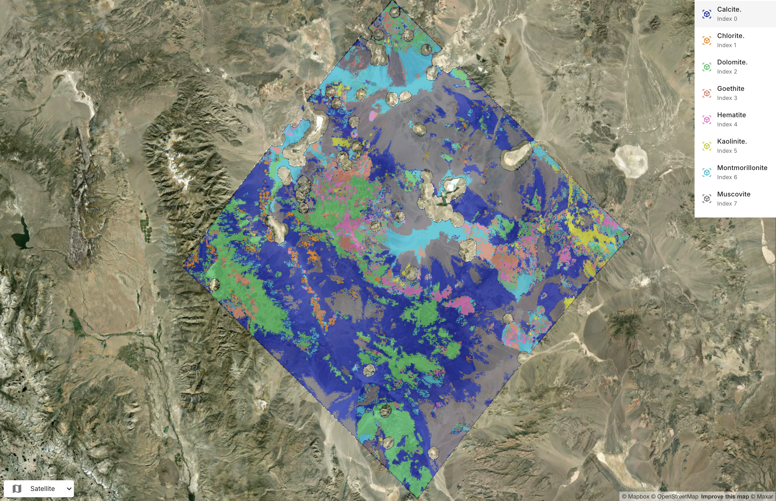
When the global model was applied to transferred Tanager imagery, it produced mineral maps with strong spatial coherence relative to the original labels at both Cuprite and the independent validation site of Ajo, Arizona.
The model accurately delineated the Cuprite hydrothermal core from its surrounding phyllic halo, and it also preserved the phyllic-to-propylitic transition in Ajo. These results show that the emulator can retain mineralogical rigor across both sensors and geographies.
It is important to note that the classification approach presented here is still a baseline. Future work aims to use unmixing networks to output fractional abundances directly, which would better represent the physical reality of Earth’s surface, where minerals rarely exist in pure, isolated pixel blocks.
The Clarity advantage
This work demonstrates that Clarity is positioned to deliver expert-level mineralogical mapping at constellation scale, autonomously and across sensors.
By packaging the rigor of USGS Tetracorder into a cloud-deployable deep learning model, Clarity enables mineral mapping operators, satellite constellation providers, and geoscience organizations to generate high-fidelity mineral products on demand from hyperspectral sensors.
The validated cross-sensor pipeline, from EMIT training to Tanager inference, establishes a practical commercial path for onboarding new sensors onto the Clarity platform with limited additional effort. Clarity’s built-in explainable AI also provides scientifically defensible, band-level transparency into every prediction, which is becoming increasingly important for trust and regulatory-facing use cases.
Talk to Metaspectral about your use case.
Bring us your material stream, imagery, or operational question and we will help scope the next evaluation.
Related Resources
More product thinking and reference material from the Metaspectral team.
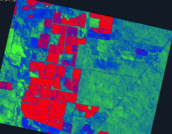
Seeing beyond the bands
Where hyperspectral analysis diverges from multispectral — and what that divergence reveals about a crop. Measured on real scenes.
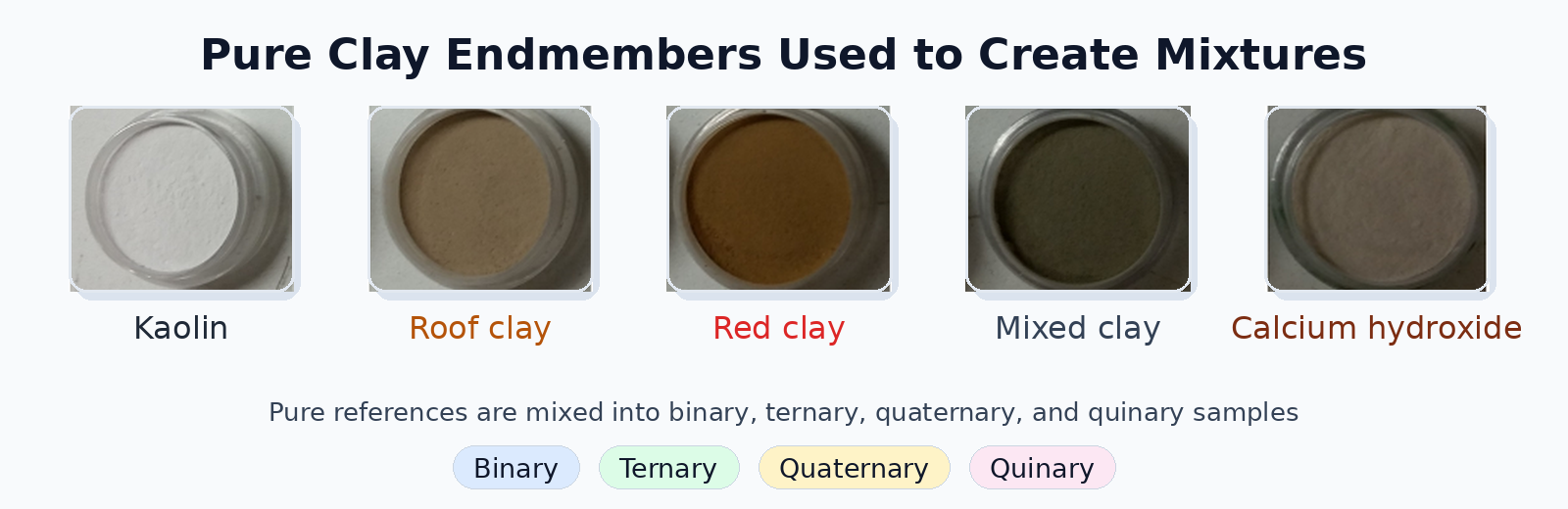
Evaluating Deep Learning Spectral Unmixing From Pure Reference Spectra
A deep learning model trained only on synthetic mixtures — generated from pure reference spectra — outperforms classical solvers on four- and five-material mixtures across nine sensors. The benchmark: 325 real clay powder mixtures measured by lab spectrometers, pushbroom cameras, snapshot cameras, MWIR, and RGB.
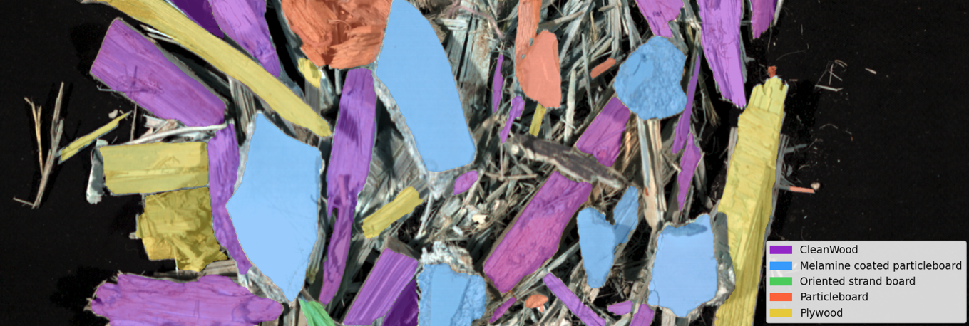
Automated Classification of Waste Wood Composites: An Evaluation of Hyperspectral Imaging and Deep Learning Pipelines
New collaborative research between UBC and Metaspectral evaluates near-infrared hyperspectral imaging and deep learning pipelines for automated classification of post-consumer waste wood composites, achieving up to 100% accuracy under controlled conditions and 91.2% on real landfill material.