Resources
Technical validation, benchmark studies, platform workflows, company updates, and educational resources from our engineering and data science teams.
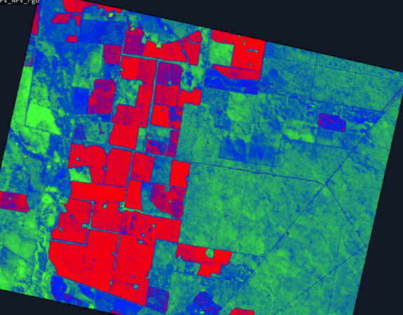
Seeing beyond the bands
Where hyperspectral analysis diverges from multispectral — and what that divergence reveals about a crop. Measured on real scenes.
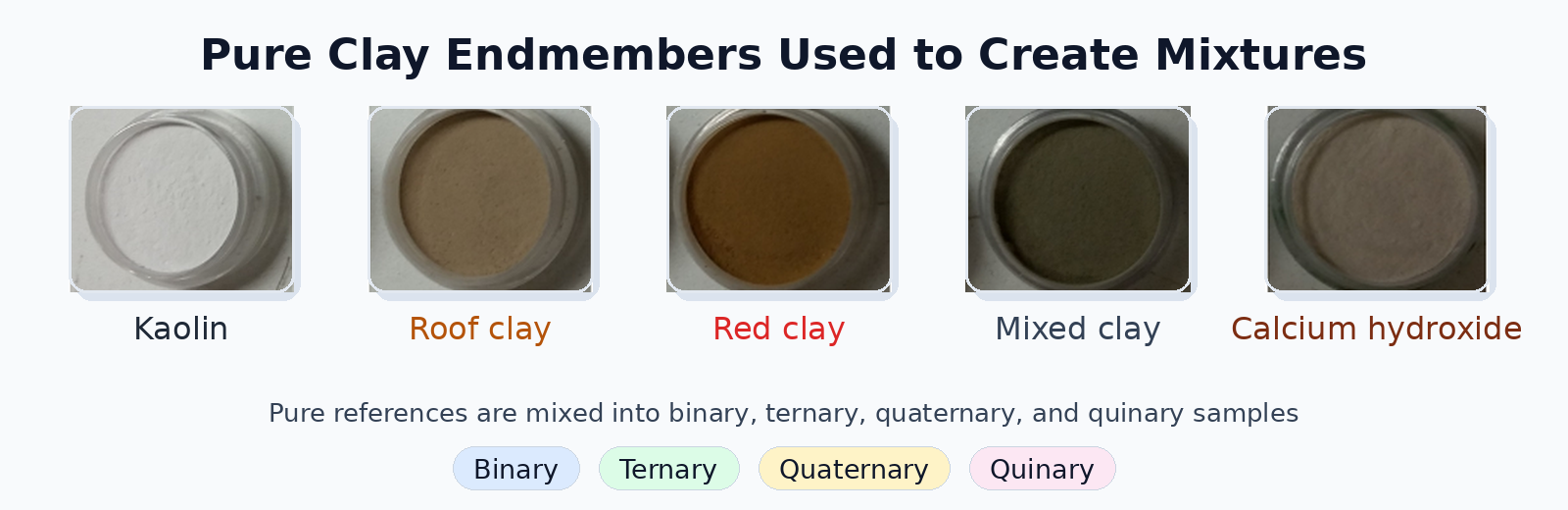
Evaluating Deep Learning Spectral Unmixing From Pure Reference Spectra
A deep learning model trained only on synthetic mixtures — generated from pure reference spectra — outperforms classical solvers on four- and five-material mixtures across nine sensors. The benchmark: 325 real clay powder mixtures measured by lab spectrometers, pushbroom cameras, snapshot cameras, MWIR, and RGB.
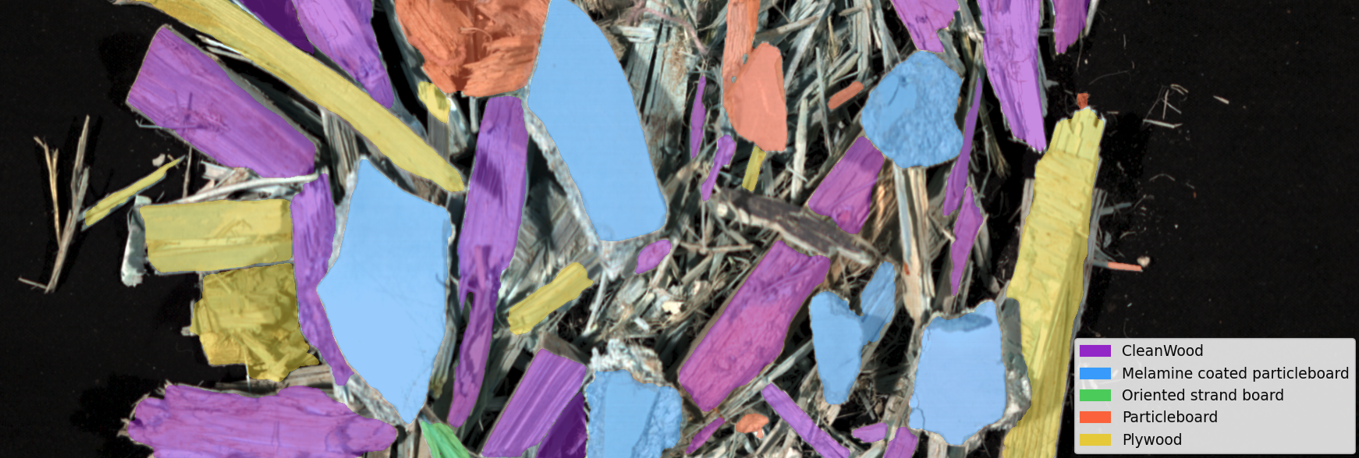
Automated Classification of Waste Wood Composites: An Evaluation of Hyperspectral Imaging and Deep Learning Pipelines
New collaborative research between UBC and Metaspectral evaluates near-infrared hyperspectral imaging and deep learning pipelines for automated classification of post-consumer waste wood composites, achieving up to 100% accuracy under controlled conditions and 91.2% on real landfill material.
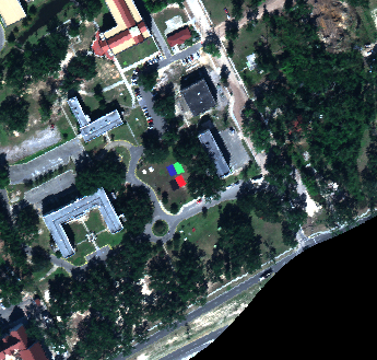
Turning One Reference Spectrum Into Full-Scene Target Detection
See how a CNN-based single-spectrum detector trained on Clarity outperformed classical baselines on full-scene MUUFL target detection across multiple train-test scene pairs.
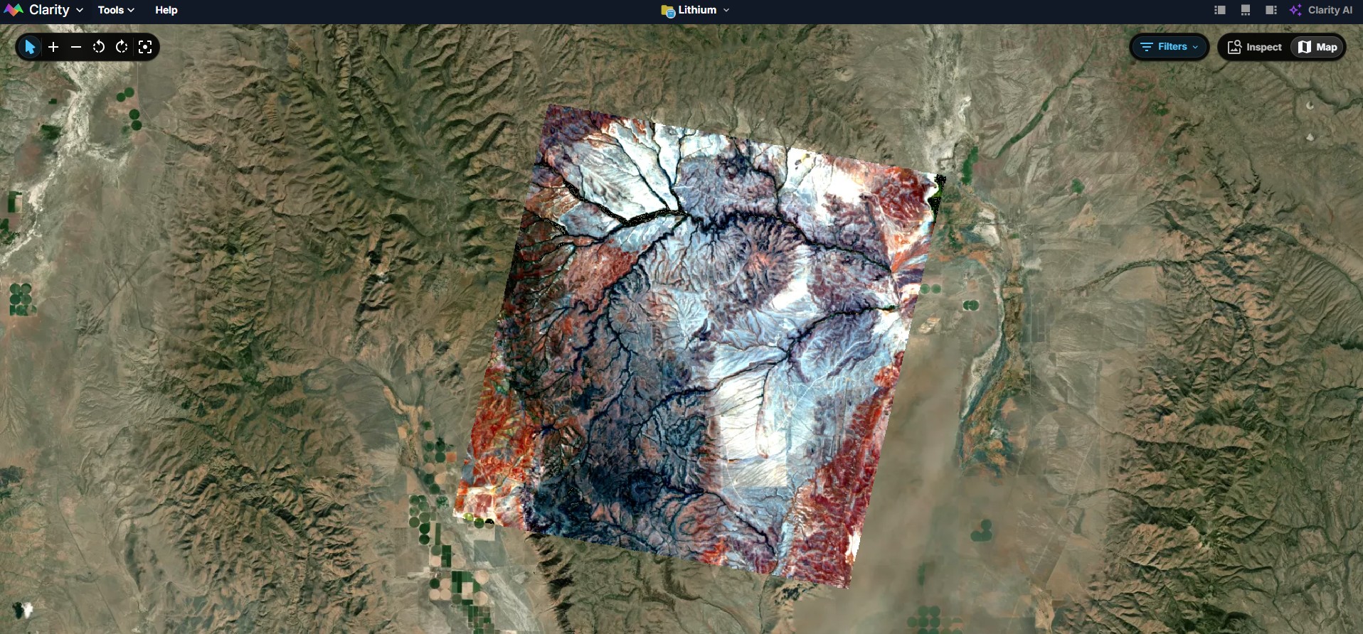
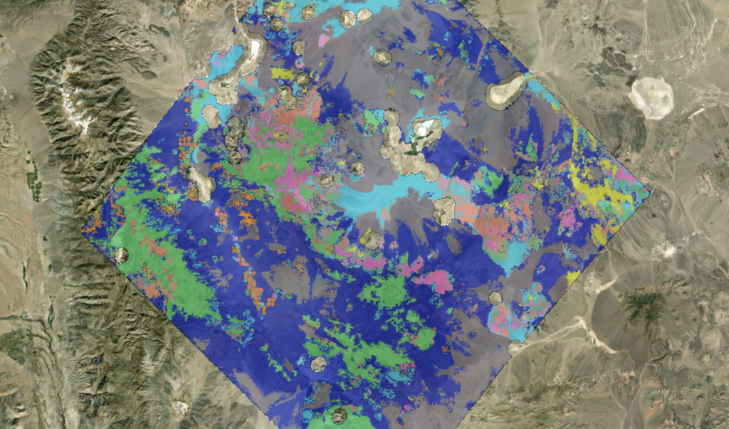
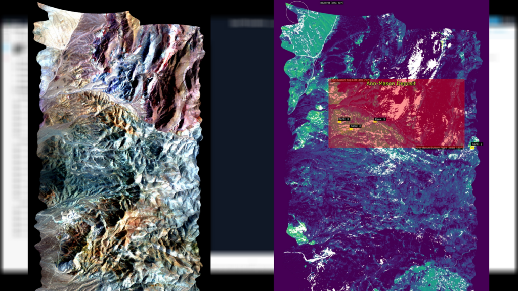
Lithium Detection over the McDermitt Deposit Using Metaspectral’s Clarity Platform
Lithium detection pipeline at the McDermitt deposit using EnMAP hyperspectral data and Metaspectral’s Clarity analysis platform.
How AI Workflows Make Hyperspectral Analysis Repeatable
Hyperspectral teams do not just need faster answers. They need a way to preserve analyst judgment, encode review logic, and apply the right process consistently across scenes, sensors, and operators. That is where workflow-based AI changes the equation.
Emulating Expert Systems for Global Mineral Mapping: Scalable, Sensor-Agnostic Mineralogical Retrieval Powered by Clarity
Metaspectral's Clarity platform delivers automated, expert-level mineral mapping from hyperspectral data, scalable across EMIT, Tanager, and next-gen satellite constellations.
Metaspectral Deep Learning Model Achieves State-of-the-Art Performances on Toulouse Hyperspectral Dataset Benchmark
Here we sought to demonstrate the efficiency and predictive power of our pixel-wise supervised CNN classifier which is benchmarked against the established baseline.
Clarity AI: A New Paradigm for Mineral Exploration
The global demand for critical minerals is surging, yet discovering new deposits remains a monumental challenge. It’s a process that has traditionally relied on decades of geological expertise, painstaking fieldwork, and expensive, speculative drilling. Hyperspectral imagery offers incredible detail and promise, but its sheer volume can be overwhelming. Exploration teams sift through mountains of geological data, searching for subtle clues buried in complex datasets.
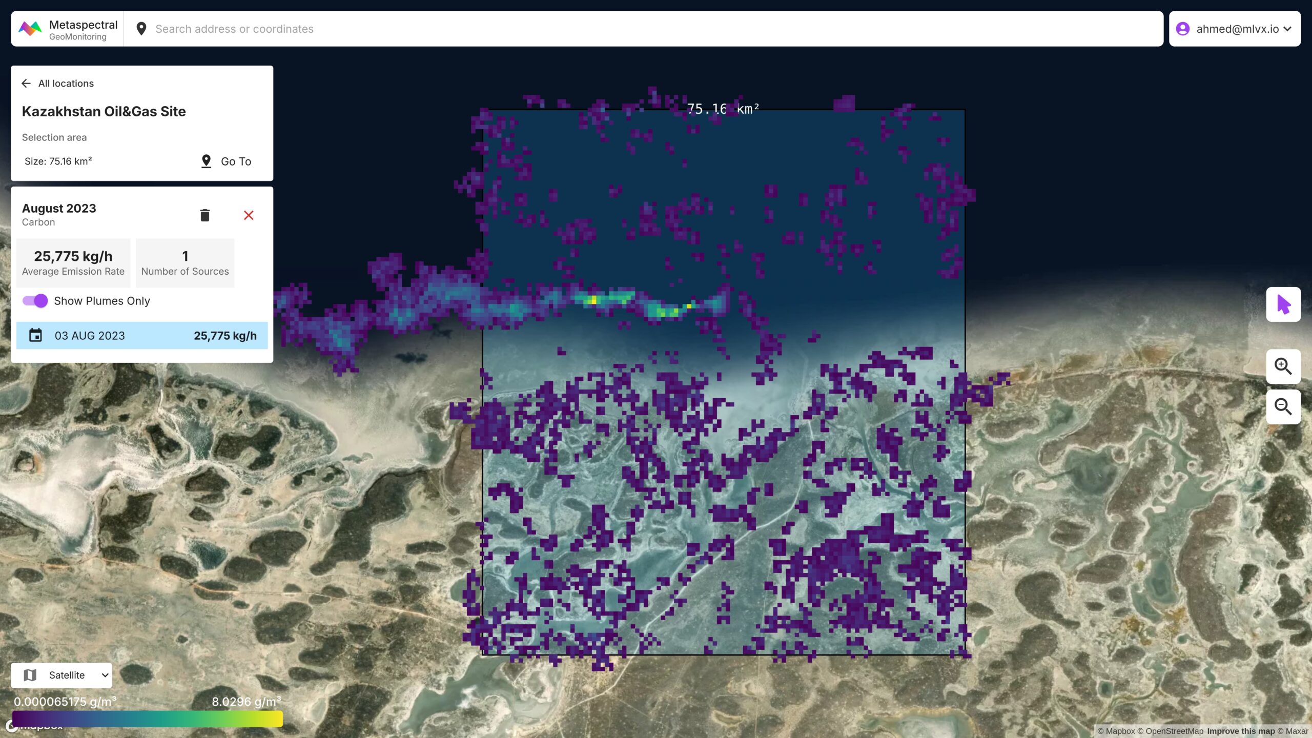
Mapping and Detection of Methane Emissions with PRISMA and ENMAP
Open-source hyperspectral imagery from PRISMA and ENMAP satellites is used to map, detect and quantify methane emissions from oil and gas leaks and landfills.
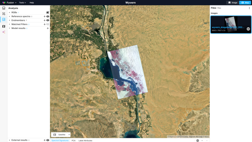
Exploring Wyvern Open Data On Metaspectral Fusion Platform
A target detection model is build to detect ships in the Suez canal from Wyvern's hyperspectral image.
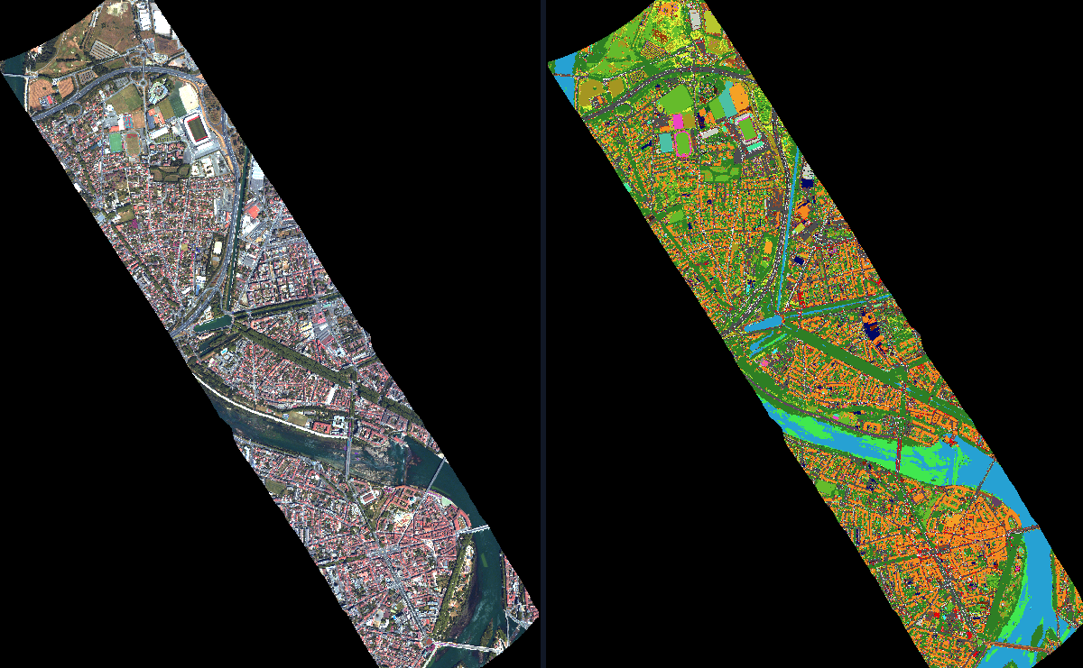
Classification, Regression and Target detection In Fusion.
Two open-source datasets are used to showcase hyperspectral data processing capabilities on the Fusion platform using deep-learning.

Metaspectral and Armada Partner to Unlock Remote Real-Time AI Analysis of Hyperspectral Imagery
Metaspectral, is partnering with Armada, an edge computing pioneer redefining the future of connectivity, compute, and artificial intelligence (AI).
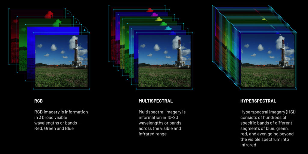
A Comprehensive Introduction to Hyperspectral Data: Unveiling the Unseen (Part I)
As we continue to push the boundaries of technology and innovation, we often find ourselves exploring realms beyond the visible, diving deep into the world of the unseen. Today, we embark on a captivating journey to understand a fascinating subject that is transforming our perception of the world: Hyperspectral Data. This post marks the beginning of a comprehensive 5-part series where we will dissect, understand, and appreciate the intricacies of this remarkable technology.

Metaspectral Secures $419K from CleanBC Plastics Action Fund
Metaspectral, has secured $419,000 from the CleanBC Plastics Action Fund, building on the previous $300,000 that the company received from the initial launch of the Fund in 2021.

Metaspectral to Bring SkyFi Satellite Imagery to its Fusion Platform
Metaspectral has executed a Letter of Intent (“LOI”) with SkyFi, a company providing on-demand satellite imagery from a growing network of over 70 satellites.

Metaspectral Selected to Join Leading Australian Space Program
The Venture Catalyst Space program is based in Adelaide, which is at the heart of Australia’s growing space sector
Measuring Ground-Level Carbon from Space
A prime use case for Metaspectral Fusion platform is to accurately quantify levels of carbon at ground-elevation using hyperspectral sensors operating in Low-Earth Orbit (LEO). Carbon is a critical component of the Earth’s climate system and plays a key role in regulating the planet’s temperature. Knowing the amount of carbon stored in the Earth’s vegetation and soil, therefore, as well as the amount of carbon present in Earth’s atmosphere, is crucial for understanding Earth’s climate and its potential impact on the environment and human populations.

How Hyperspectral Imaging is Revolutionizing Industrial Recycling
In a world where sustainability is becoming increasingly important, industrial recycling facilities are a powerful way to reduce waste and turn it into something useful. But how can we ensure that the materials being recycled are sorted accurately and efficiently? Hyperspectral imaging offers a powerful solution in situations where conventional computer vision based systems fail.

Metaspectral Raises $4.7 Million to Launch Fusion, a Cloud-Based AI Platform
Fusion performs deep learning (AI) analysis on hyperspectral imagery to identify materials and their invisible properties in real-time. Metaspectral has completed a $4.7 million seed round from SOMA Capital, Acequia Capital, the Government of Canada, and others.

Rust Detection with Hyperspectral Imaging
Rust is a major problem for naval vessels because it causes structural damage and can lead to leaks. Because of this, detecting rust early is crucial for naval maintenance. However, traditional methods of rust detection, such as close visual inspection, are time-consuming and often ineffective.
Imagining the Possibilities: Hyperspectral Imaging in Agriculture
Hyperspectral imaging is a remote sensing technology that can be used to collect data about the physical and chemical properties of an object, scene, or area. In the past, hyperspectral imaging systems were too large, too expensive, and required too much power to be practical for use in agriculture. However, recent advances in technology have made hyperspectral imaging more affordable and accessible than ever before. Farmers can now use hyperspectral imaging to collect detailed information about their crops, soil, and water resources.
What is hyperspectral imaging and why does it matter?
If you’ve ever wondered how those jaw-dropping images of galaxies or nebulae are captured, the answer lies in hyperspectral imaging. This powerful tool allows us to see things that our eyes cannot, and it has a range of applications in both the scientific and commercial realms. Let’s take a closer look at hyperspectral imaging and how it works.
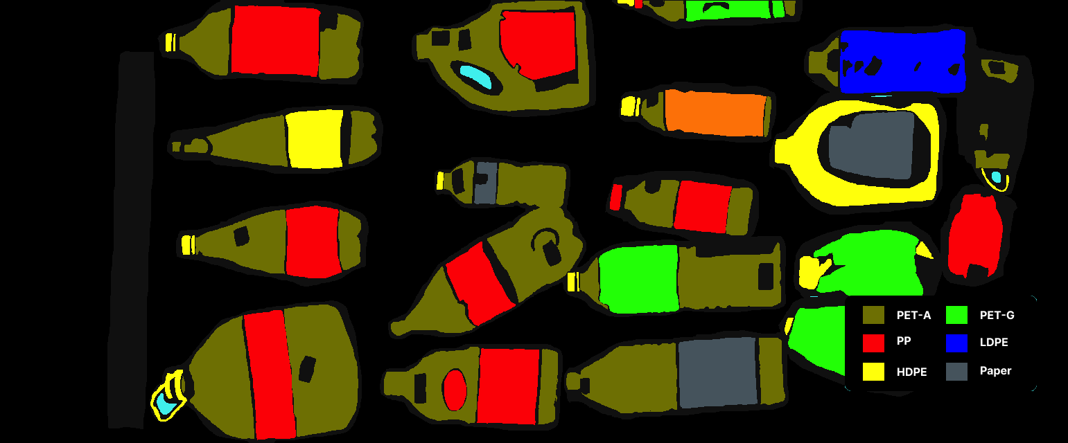
Benefits of Hyperspectral Data Analysis for Plastic Recycling
As the recycling industry looks for ways to become more efficient and effective, many operators are turning to hyperspectral data analysis as a solution. Hyperspectral data analysis is a form of spectroscopy that can identify the chemical properties of objects. This information can then be used to sort and recycle materials more effectively.